LIVE WEBCAM OF EYJAFJALLAJOKULL VOLCANO
Eruption were reported to start on March 17, 2010 The erruption in March 24-30 March were fissure type. Also, local scientist reported 4-5 active craters and 200m lava-fall into the Hruna Canyon. On March 26, the lava flow changed its course down 100m to Hvanna Canyon. From a helicopter on 28 March, scientists saw lava flowing into both canyons and noted fewer jets of lava. The next evening a swarm of earthquakes in the region measuring M 2-2.5 were detected. A geophysicist noted that seismicity was gradually decreasing. The volcano have covered an area as big as 1 square km with 10-20 m thick lava. An Earthquake scaled at 3,7 M detected in erruption zone on April 6, 2010. On April 13, 2010 eruption rate is decreased to pre-eruption level, but subglacial eruption occured on April 14, 2010 from a new vent located West of the old one. Water from melting glacier flow to N and E, causing road closures, evacuation of 700 inhabitants, and flight bannings. Iceland Police Office had reported that 25,000 people had visited the eruption site since it started on March 2010.In 16 April, 2010, Ash cloud were reported to fly as high as 30,000 ft or 9 km.
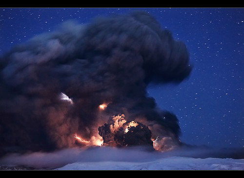
22 Lightning Strikes were observed in eruption site from April 16 2010 00.00 GMT to April 17, 2010 04.36 GMT. Some minor earthquakes measuring 1.2-2.3 on the Richter scale were also measured during that time period. The eruption continued with constant force last night but after 4:30 it was somewhat weakened. The spout reached a height of 8.5 kilometers, ruv.is reports. There is still significant ash fall in the immediate area—it is very dark at the foot of the glacier. The ash cloud is dense from Núpur in the west to Vík in the east but there is not as much ash fall in the Mýrdalssandur sand plain east of Vík anymore.
NOW (APRIL 19,2010) LIMITED AIRBORNE TRAFFIC IS PERMITTED ALL OVER EUROPE AFTER A 5-DAY BANNING!
Eyjafjoll a.k.a Eyjafjallajokul is an andesite stratovolcano with caldera in its top. This volcano lies directly on the divergent tectonic boundary which continued from South Atlantic and after passing the Iceland this boundary goes to the north pole. Along with Surtsey and Hekla, this volcano also lies in the southern shore of Iceland.
Compare Eyjafjallajokull to this VEI 6 PINATUBO ERUPTION:

No comments:
Post a Comment