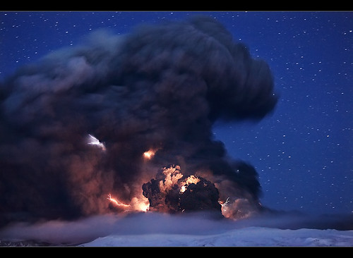
Mount Sinabung is a 2 460 meters high Pleistocene-to-Holocene stratovolcano located in Tanah Karo Regency, North Sumatra Province of Indonesia. The migration of summit vents along N-S trending line has given an elongated form of its summit. The youngest crater of this conical andecitic to dacitic stratovolcano is at southern end of four overlapping craters. Solfataric activity WAS seen on its summit and upper flanks of Sinabung in 1912. there is no historical record of Sinabung eruption before today, as volcanological data from Indonesian Volcanism Bureau had been classified this volcano in Type B volcano, meaning that this volcano is never erupted before 1600 AD and features volcanic activity. Because it was included as a Type B volcano, (until today) there is no volcanism observatory at this mountain. All volcanic activity is observed from Medan. Now this volcano is classified into Type A, meaning that there is a known historical eruption of the volcano after 1600 AD.

Surono, the chairman of Geologic Hazard Mitigation and Volcanism Center was swear, "if Sinabung Volcano is gonna erupt, i have to put my position as a chairman". Now, the Sinabung volcano is erupt and i beg your swear! :-)
Aids has came to the disaster-affected region. The aids are mostly came in form of maskings, 75 government officers, foods, and other kind of logistics. I predicted that the ash from Sinabung will interfere some flight schedules from International Airport of Polonia 3 days from now, the cause is the ash will be directed North East. (based on GFS model).
SATURDAY, AUGUST 28, 2010
05.04 AM GMT (12.04 PM local time)
Sinabung volcano's activity is increasing, signed by the release of hot gases and water vapor. Lahars and ash rain is also reported by people living on Sinabung's flank. Villagers also heared thundering sound from the volcano. Some 26 000 villagers has fled to nearby city centers: Kabanjahe and Brastagi, also Medan and Pematang Siantar. They are evacuated to church and mosques and other social facilities. They don't want to go home before the official stated that the condition is secure.
5 years ago the Sinabung volcano was rumbling and roaring then followed with avalanche. However, it was not categorized as volcanic eruption.
05.15 PM GMT (Sunday, August 29, 2010--00.15 AM local time)
I take attention of this volcano due to its reactivation after a very long quiescense
2 460 m Sinabung volcano started releasing molten lava. the lava fountain is visible from afar, spewing lava into the night sky and flow some into the flank. Hot ash with white to yellow color is spread into areas located tens kilometers. But in the morning, the lava fountain is not visible due to foggy weather.
03.00 AM GMT, Sunday, August 29, 2010
Refugees do riot at Regent's house asking for foods. They had been waiting for 8 hours in refuge camp. After the riot finished, the foods then came.
07.36 AM GMT, Sunday, August 29, 2010
One dies due to respiratory problem caused by Sinabung's ash.
10.37 AM GMT, Sunday, August 29, 2010
Geologists has sent to eruption site for determining whether the erupted material is containing Silicon. if the erupted material is containing silicon then the eruption is explosive and will last for months. That kind of long eruption was happened to Galungggung Volcano in West Java Province of Indonesia. The Galunggung volcano was slept since before 1600, then it awakes at 1983, caused 10 moths long explosive eruption.
10.00 PM GMT, Sunday, August 29, 2010
A 5-minute quake rattled villages near Mount Sinabung.
Early Morning of Friday, Sep 3, 2010 Local Time: Sinabung erupted for the second time.
COMPILED VIDEO OF SINABUNG ERUPTION
From August 29 - 30, 2010
I take attention of this volcano due to its reactivation after a very long quiescense
Sources:
thejakartapost.com (English)
ANTARA (English)
metrotvnews.com (Indonesian Language)
kompas.com (Indonesian Language)
volcano.si.edu (Smithsonian Volcanism Site)