In response to the X class flare ( Intensity being estimated) by the Sunspot 1429,A former R3 now R2 Radio Blackout is affecting the sunlit side of the Earth
As seen from this image,the higher frequency signals are being largely attenuated due to the Radio Disturbance as the signals propogate through a disturbed ionosphere..
Monday, March 5, 2012


Mega Solar Flare from Sunspot 1429!!
SEVERE SOLARWX
AKSHAY DEORAS
SEVERE WEATHER FORECASTER
AKSHAY DEORAS
SEVERE WEATHER FORECASTER
AFTER A BRIEF PERIOD OF QUIET SPACE WEATHER,OUR SUN IS WAKING UP DUE TO THE SUNSPOT AE 1429. The Sunspot is 4 times the size of the Earth.
The GOES X Ray flux is indicating a major Solar Flare in progress and a R3 Radio Blackout is in progress on the Sunlit side of the earth including here in India at the Higher Frequency
Solar disc is rotating and hence the sunspot 1429 will become geoeffective after some days... If it hurls another X class flare then that may be a source of big problem
Stay tuned as the event unfurls
Wednesday, February 29, 2012
Is the Sun really heading for Solar Maximum?
SEVERE SOLARWX


Akshay Deoras
Severe Weather Forecaster
With less than a year away from the forecasted Solar Maximum of Solar Cycle 24, the sunspot activity has flattened since the beginning of this year. The Sun which was hyper active in terms of its Sunspot Number ( Daily and monthly) is quiet these days with practically few weak ( Magnetically stable configuration). The datas from IPS Solar indicate that the Sunspot no. of January 2012 has been 58.3 as against the predicted 74.8 and 73.0 of December 2011.
Just to remind that the Sunspot no. had reached a peak of 96.7 in Nov 2011 which was far higher than 67.7 predicted.
Below-
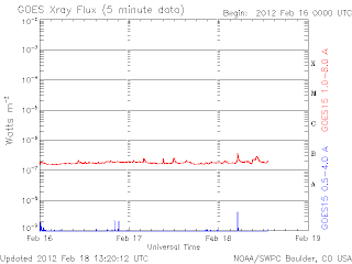
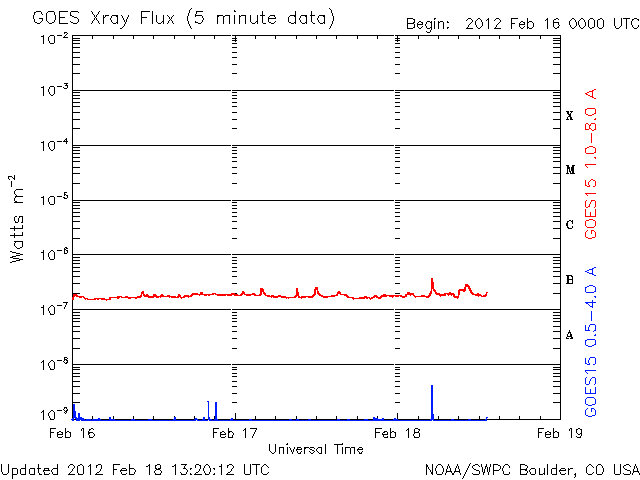
The GOES X ray flux between the period Feb 16-19 and Feb 27-present shows flattened X ray output of the sun.
This scenario has been very common since this year!

Seen below is a plot of Solar Activity Level during the period 30th Jan - 28th Feb 2012 indicating Solar Activity level flat at low or very low except for 06th Feb 2012. The below plot considers the overall Solar Flares and CME from the sun.

These are just preliminary datas. I shall write in details around 17th March 2012 considering the new parameters
Akshay Deoras
Severe Earth & Space Weather Forecaster,Astrophysics article writer.www.scribd.com/akshaydeoras
Web-
www.akshaydeoras.blogspot.com
www.metdweather.blogspot.com
Tuesday, February 14, 2012
Static Instability
Alutsyah Luthfian | Create Your Badge

While seeing the weatherman said "It gonna be rain in Jakarta tomorrow", a critical person should think what mechanism driving the air to put down some of it moisture. He would run for YouTube, chasing the lapse rate videos showing the grow of cloud over time. Then he could also run for satellite images seeing the case of it. Then he would got a simple conclusion that the water vapor rises high to the sky and it cools down, and after that it rains. Then he asked again to himself, how a cloud could rise? Why not all cloud rising and pour rain? Then he may google it up and found articles talking about it. Some articles said that convective energy available in a specific area governs that. It may say that convective energy, is related to static instability.
Here, i just trying to talk about static instability. In meteorology, especially the one talking about weather phenomenon happening at the spatial scale of 2 - 2000 km (mesoscale), there are 5 types of instability: Static instability, Inertial instability, Shear instability, Symmetric instability, and Centrifugal instability. Each type of instability has their own use. The static instability is used to determine whether a place is potential for thunderstorm buildup or no. Even in tornadogenesis, static instability plays a great role in determining how powerful the tornado will be.
Let we consider a piece of air parcel trying to rise in the sky. The vector working at this air parcel is buoyancy B defined as these. \[\overrightarrow B = \overrightarrow g \cdot \frac{{\left( {T - \overline T } \right)}}{{\overline T }}\] For sure, because of buoyancy, the parcel of air is rising. Let's see that Newton's Law stated a force has acceleration, so then we can infer that the buoyancy force accelerates the air parcel upward against gravitational force, $\overrightarrow B = \frac{{d\overrightarrow w }}{{dt}}$, $\overrightarrow w$ is upward velocity. We also know that the upward velocity $\overrightarrow w = \frac{{d\overrightarrow {\Delta z} }}{{dt}}$ for ${\overrightarrow {\Delta z} }$ is displacement along the troposphere's depth. Then, we could describe the buoyancy force in more intricating form like these. \[\frac{{{d^2}\overrightarrow {\Delta z} }}{{d{t^2}}} = g \cdot \frac{{\left( {T - \overline T } \right)}}{{\overline T }}\] Now its the time to talk about the two kinds of T in equation above. The $T$ stands for air parcel temperature and the $\overline T $ stands for environmental temperature.
In meteorology, the $T$ and $\overline T $ are actually changing with height. We usually says that temperature decreases with height, but let us change that view: in case of air inversion caused when hot air is advected to a cooler region, air aloft is warmer than that of surface, so we better describe temperature as a continuous function of z; $T\left( z \right)$ and $\overline T \left( z \right)$. Then, if we fly from height z0 to height a in troposphere,
${\Gamma _p} = T'\left( z_0 \right) \to \frac{{\partial T}}{{\partial z}}$, the change of air parcel temperature with the change of height and
$\gamma = \overline {T} '\left( {z_0} \right) \to \frac{{\partial \overline T }}{{\partial z}}$, the change of environmental air temperature as the height changes, so $T$ and $\overline T $ equals to:
The first state of air parcel in atmosphere is always equilibrum, means that air parcel temperature is the same with environmental temperature (${T_0} = {\overline T _0}$), so that equation (7.) and (8.) finally become:
Reviewing the equation for $\overrightarrow B$, let us analyze it in depth.
 ).
).
After changing the equation (15.) into complex form and taking just the real part, then we obtain this very (16.) equation.
If ${\Gamma _p}<{\gamma }$, then $i{\left[ {{\textstyle{g \over {{T_0}}}}\left( {{\Gamma _p} - \gamma } \right)} \right]^{{\textstyle{1 \over 2}}}}$ becomes real. When the t is very big, the C1 can be ignored, and the equation would be like this.
From the buoyancy equation above, an air parcel can only rise automatically if the temperature of air parcel is warmer than the environmental temperature. The level where the air parcel becomes warmer than the environmental temperature is called Level of Free Convection or LFC. Other point important in determining CAPE is equilibrum level, is when the air parcel temperature cools down to be the same with environmental temperature again.
This is the skew-T log-P plot showing CAPE, level of free convection, and equilibrum level.

Deriving CAPE:
What drive cloud to pour rain? It is instability. Instability is driven by difference between air parcel temperature and environmental temperature. The more moisture an air parcel has, its lapse rate would be smaller (remember that water vapor is a good heat storage). Also, sky above a suburb or city is normally has bigger lapse rate compared to a field or forest. Steep lapse rate also experienced in frontal boundary. In mountains, the environmental lapse rate experienced there is a mix between horizontal and vertical environmental lapse rate, and that two are always big there. Big lapse rate of environment added with small lapse rate of air parcel would make the air parcel rise. The rising air parcel cools into water dropplet or ice (if the buoyancy is great), graupel or snow (if buoyancy is just positive). A tremendous buoyancy will turn the air parcels into a tremendous castle of cumulonimbus cloud - that's why forecasters uses CAPE as a parameter for determining thunderstorm. Buoyancy can even tilt a horizontally aligned rotational motion of air into an EF-5 wedge tornado. The buoyancy of air parcel in sea is relatively smaller than that of land (except in equator where the air parcel is forcedly lifted), because the environmental lapse rate is small, and so does the parcel lapse rate. In desert, the air parcel is mostly dry, so its lapse rate is big, along with the environmental lapse rate. What about hurricane forming in the sea? It is the case of shear instability, that later turned on the static instability and moreover, the inertial instability. Not all cloud pouring rain, because:
While seeing the weatherman said "It gonna be rain in Jakarta tomorrow", a critical person should think what mechanism driving the air to put down some of it moisture. He would run for YouTube, chasing the lapse rate videos showing the grow of cloud over time. Then he could also run for satellite images seeing the case of it. Then he would got a simple conclusion that the water vapor rises high to the sky and it cools down, and after that it rains. Then he asked again to himself, how a cloud could rise? Why not all cloud rising and pour rain? Then he may google it up and found articles talking about it. Some articles said that convective energy available in a specific area governs that. It may say that convective energy, is related to static instability.
Here, i just trying to talk about static instability. In meteorology, especially the one talking about weather phenomenon happening at the spatial scale of 2 - 2000 km (mesoscale), there are 5 types of instability: Static instability, Inertial instability, Shear instability, Symmetric instability, and Centrifugal instability. Each type of instability has their own use. The static instability is used to determine whether a place is potential for thunderstorm buildup or no. Even in tornadogenesis, static instability plays a great role in determining how powerful the tornado will be.
Formulation of Buoyancy
Let we consider a piece of air parcel trying to rise in the sky. The vector working at this air parcel is buoyancy B defined as these. \[\overrightarrow B = \overrightarrow g \cdot \frac{{\left( {T - \overline T } \right)}}{{\overline T }}\] For sure, because of buoyancy, the parcel of air is rising. Let's see that Newton's Law stated a force has acceleration, so then we can infer that the buoyancy force accelerates the air parcel upward against gravitational force, $\overrightarrow B = \frac{{d\overrightarrow w }}{{dt}}$, $\overrightarrow w$ is upward velocity. We also know that the upward velocity $\overrightarrow w = \frac{{d\overrightarrow {\Delta z} }}{{dt}}$ for ${\overrightarrow {\Delta z} }$ is displacement along the troposphere's depth. Then, we could describe the buoyancy force in more intricating form like these. \[\frac{{{d^2}\overrightarrow {\Delta z} }}{{d{t^2}}} = g \cdot \frac{{\left( {T - \overline T } \right)}}{{\overline T }}\] Now its the time to talk about the two kinds of T in equation above. The $T$ stands for air parcel temperature and the $\overline T $ stands for environmental temperature.
Breaking Apart the $T$ and $\overline T $
In meteorology, the $T$ and $\overline T $ are actually changing with height. We usually says that temperature decreases with height, but let us change that view: in case of air inversion caused when hot air is advected to a cooler region, air aloft is warmer than that of surface, so we better describe temperature as a continuous function of z; $T\left( z \right)$ and $\overline T \left( z \right)$. Then, if we fly from height z0 to height a in troposphere,
- \[T\left( a \right) - T\left( z_0 \right) = \int\limits_{{z_0}}^a {T'\left( z \right)dz} \]
- \[\overline T \left( a \right) - \overline T \left( z_0 \right) = \int\limits_{{z_0}}^a {\overline T '\left( z \right)dz} \]
- \[T\left( a \right) - T\left( {{z_0}} \right) = T'\left( z_0 \right)\left( {a - {z_0}} \right) + \int\limits_{{z_0}}^a {\left( {a - z} \right)T''\left( z \right)dz} \]
- \[\overline T \left( a \right) - \overline T \left( {{z_0}} \right) = \overline T '\left( z_0 \right)\left( {a - z_0} \right) + \int\limits_{{z_0}}^a {\left( {a - {z}} \right)\overline T ''\left( z \right)dz} \]
- Temperature of air parcel at height a
\[T\left( a \right) = T\left( {{z_0}} \right) + T'\left( {{z_0}} \right)\left( {a - {z_0}} \right) + ... + \frac{{{T^n}\left( {{z_0}} \right)}}{{n!}}{\left( {a - {z_0}} \right)^n}\] - Temperature of environment at height a
\[\overline T \left( a \right) = \overline T \left( {{z_0}} \right) + \overline T '\left( {{z_0}} \right)\left( {a - {z_0}} \right) + ... + \frac{{{{\overline T }^n}\left( {{z_0}} \right)}}{{n!}}{\left( {a - {z_0}} \right)^n}\]
${\Gamma _p} = T'\left( z_0 \right) \to \frac{{\partial T}}{{\partial z}}$, the change of air parcel temperature with the change of height and
$\gamma = \overline {T} '\left( {z_0} \right) \to \frac{{\partial \overline T }}{{\partial z}}$, the change of environmental air temperature as the height changes, so $T$ and $\overline T $ equals to:
- \[T = {T_0} + {\Gamma _p}\left( {\Delta z} \right)\]
- \[\overline T = {\overline T _0} + \gamma \left( {\Delta z} \right)\]
The first state of air parcel in atmosphere is always equilibrum, means that air parcel temperature is the same with environmental temperature (${T_0} = {\overline T _0}$), so that equation (7.) and (8.) finally become:
- \[T = {T_0} + {\Gamma _p}\left( {\Delta z} \right)\]
- \[\overline T = {T _0} + \gamma \left( {\Delta z} \right)\]
Stability of Environmental Lapse Rate
Reviewing the equation for $\overrightarrow B$, let us analyze it in depth.
- \[\overrightarrow B = \overrightarrow g \cdot \frac{{\left( {T - \overline T } \right)}}{{\overline T }}\]
- \[\frac{{{d^2}\overrightarrow {\Delta z} }}{{d{t^2}}} = \overrightarrow g \frac{{\left( {{T_0} - {\Gamma _p} \cdot \Delta z - {T_0} + \gamma \cdot \Delta z} \right)}}{{{T_0} - \gamma \cdot \Delta z}}\]
- \[\frac{{{d^2}\overrightarrow {\Delta z} }}{{d{t^2}}} = - \overrightarrow g \Delta z\frac{{\left( {{\Gamma _p} - \gamma } \right)}}{{{T_0} - \gamma \cdot \Delta z}}\]
- \[\frac{{{d^2}\overrightarrow {\Delta z} }}{{d{t^2}}} + \overrightarrow g \Delta x\frac{{\left( {{\Gamma _p} - \gamma } \right)}}{{{T_0}}} = 0\]
- \[\Delta z\left( t \right) = {C_1} \cdot {e^{i{{\left[ {{\textstyle{g \over {{T_0}}}}\left( {{\Gamma _p} - \gamma } \right)} \right]}^{\frac{1}{2}}}t}} + {C_2} \cdot {e^{ - i{{\left[ {{\textstyle{g \over {{T_0}}}}\left( {{\Gamma _p} - \gamma } \right)} \right]}^{\frac{1}{2}}}t}}\]
$C_1$ and $C_2$ is a constant depending on the magnitude and direction of initial parcel displacement. We don't use vector here because we emphasize the quantity of the vector as a function of time.
 ).
).
After changing the equation (15.) into complex form and taking just the real part, then we obtain this very (16.) equation.
- \[\Delta z\left( t \right) = \left( {{C_1} + {C_2}} \right) \cdot \cos \left\{ {{{\left[ {{\textstyle{g \over {{T_0}}}}\left( {{\Gamma _p} - \gamma } \right)} \right]}^{{\textstyle{1 \over 2}}}}t} \right\}\]
If ${\Gamma _p}<{\gamma }$, then $i{\left[ {{\textstyle{g \over {{T_0}}}}\left( {{\Gamma _p} - \gamma } \right)} \right]^{{\textstyle{1 \over 2}}}}$ becomes real. When the t is very big, the C1 can be ignored, and the equation would be like this.
- \[\Delta z\left( t \right) = {C_2}{e^{{{\left[ {{\textstyle{g \over {{T_0}}}}\left( {\gamma - {\Gamma _p}} \right)} \right]}^{{\textstyle{1 \over 2}}}}t}}\]
Convective Available Potential Energy (CAPE)
From the buoyancy equation above, an air parcel can only rise automatically if the temperature of air parcel is warmer than the environmental temperature. The level where the air parcel becomes warmer than the environmental temperature is called Level of Free Convection or LFC. Other point important in determining CAPE is equilibrum level, is when the air parcel temperature cools down to be the same with environmental temperature again.
This is the skew-T log-P plot showing CAPE, level of free convection, and equilibrum level.

Deriving CAPE:
- \[\frac{{d\overrightarrow w }}{{dt}} = \overrightarrow B \]
- Multiplying (18.) with $\overrightarrow w \equiv \frac{{d\overrightarrow z }}{{dt}}$
\[\overrightarrow w \frac{{d\overrightarrow w }}{{dt}} = \overrightarrow B \frac{{d\overrightarrow z }}{{dt}}\] - \[\frac{d}{{dt}}\left( {\frac{{{{\overrightarrow w }^2}}}{2}} \right) = \overrightarrow B \frac{{d\overrightarrow z }}{{dt}}\]
- Canceling the $dt$, and integrating (20.) from LFC from EL.
\[\int\limits_{LFC}^{EL} {d{{\overrightarrow w }^2}} = 2\int\limits_{LFC}^{EL} {\overrightarrow B \cdot d\overrightarrow z } \] - Vector dot product is scalar. So then,
\[w_{EL}^2 - w_{LFC}^2 = 2\left[ {CAPE} \right]\] - Since the vertical velocity $w$ at level of free convection equals 0, so vertical velocity at equilibrum level is considered maximum. Then,
\[w_{EL}^2 = 2\left[ {CAPE} \right]\] - \[\frac{1}{2} \cdot w_{EL}^2 = CAPE\]
Putting All Above Together
What drive cloud to pour rain? It is instability. Instability is driven by difference between air parcel temperature and environmental temperature. The more moisture an air parcel has, its lapse rate would be smaller (remember that water vapor is a good heat storage). Also, sky above a suburb or city is normally has bigger lapse rate compared to a field or forest. Steep lapse rate also experienced in frontal boundary. In mountains, the environmental lapse rate experienced there is a mix between horizontal and vertical environmental lapse rate, and that two are always big there. Big lapse rate of environment added with small lapse rate of air parcel would make the air parcel rise. The rising air parcel cools into water dropplet or ice (if the buoyancy is great), graupel or snow (if buoyancy is just positive). A tremendous buoyancy will turn the air parcels into a tremendous castle of cumulonimbus cloud - that's why forecasters uses CAPE as a parameter for determining thunderstorm. Buoyancy can even tilt a horizontally aligned rotational motion of air into an EF-5 wedge tornado. The buoyancy of air parcel in sea is relatively smaller than that of land (except in equator where the air parcel is forcedly lifted), because the environmental lapse rate is small, and so does the parcel lapse rate. In desert, the air parcel is mostly dry, so its lapse rate is big, along with the environmental lapse rate. What about hurricane forming in the sea? It is the case of shear instability, that later turned on the static instability and moreover, the inertial instability. Not all cloud pouring rain, because:
- Clouds have different rate of inner instability depending on their origin. The most unstable one will perform convection and possible to pour rain.
- The environmental lapse rate should be adequate to fire convection if no cloud is sufficiently unstable.
Wednesday, February 8, 2012
Prime numbers
Prime numbers are infintely many. But the chances of finding it when we count on very large figures, approaches zero - but it will never be zero probability in finding prime numbers. Just like addition of 1/2 + 1/3 + 1/4 + ..., the figure of 1/n approaches zero, but its sum is infinite. :-)
-ALUTSYAH LUTHFIAN-
-ALUTSYAH LUTHFIAN-
Tuesday, January 24, 2012
Geomagnetic Sudden Impulse! CME arrives earlier than SSW forecast

AKSHAY DEORAS
SEVERE WEATHER FORECASTER
THE CME FROM THE JAN 23RD SOLAR FLARE HAS ARRIVED AND HAS CAUSED A GEOMAGNETIC SUDDEN IMPULSE.
STAY TUNED FOR MORE UPDATES!
Akshay Deoras
www.akshaydeoras.blogspot.com
www.metdweather.blogspot.com
Major Geomagnetic Storming expected due to CME of M9 class flare
SEVERE SOLARWX
Akshay Deoras
Severe Weather Forecaster
A MAJOR GEOMAGNETIC STORMING IS LIKELY FROM TONIGHT ( GMT) OVER 25TH JAN 2012
The Mega-flare of January 23rd, which released massive and very very fast moving CME towards the Earth is expected to cause a Major Geomagnetic Storming. Initial estimates from the Goddard Space Flight Center confirm that the CME speed was over 2200km/sec when released !
The arriving models are confirming that the CME is Earth-directed and likely to hit the Earth's Magnetic Field on night hours of 24th Jan 2012 today ( GMT).
As the momentum of CME is very high, it will definitely give a very strong hit to the Earth's magnetic field which definitely will trigger Major Geomagnetic Storm
The estimates are suggesting that the Geomagnetic Storming level can reach upto G3 level which the Space Weather Prediction Center of NOAA also suggests.
Attached below is the model which shows the approaching CME

Below model image shows CME just before the impact-

Highlights-
A VERY STRONG CME IS HEADING TOWARDS THE EARTH AND WILL HIT THE EARTH'S MAGNETIC FIELD ON NIGHT HOURS ( GMT) OF 24TH JAN 2012
* A MODERATE TO STRONG GEOMAGNETIC STORM UPTO G3 LEVEL IS EXPECTED DUE TO IT

* THE MEGA FLARE ALSO BOOSTED SOLAR PROTONS WHICH HAS CAUSED A S3 LEVEL SOLAR RADIATION STORM WHICH LAST HAPPENED IN 2005.
* THE FLIGHTS TRAVELLING IN POLAR ORBIT ( POLAR ROUTE) WERE EXPECTED TO MAKE A PATH CHANGE TO AVOID EXPOSURE TO RADIATION!
* THE CME WILL SPARKLE AURORAS IN HIGH LATITUDE AND LIKELY IN LOW LATITUDE AREAS ALSO.
STAY TUNED FOR UPDATES @
http://www.facebook.com/pages/Severe-Solar-Weather-forecast/112556765473804
Akshay Deoras
Severe Weather Forecaster
A MAJOR GEOMAGNETIC STORMING IS LIKELY FROM TONIGHT ( GMT) OVER 25TH JAN 2012
The Mega-flare of January 23rd, which released massive and very very fast moving CME towards the Earth is expected to cause a Major Geomagnetic Storming. Initial estimates from the Goddard Space Flight Center confirm that the CME speed was over 2200km/sec when released !
The arriving models are confirming that the CME is Earth-directed and likely to hit the Earth's Magnetic Field on night hours of 24th Jan 2012 today ( GMT).
As the momentum of CME is very high, it will definitely give a very strong hit to the Earth's magnetic field which definitely will trigger Major Geomagnetic Storm
The estimates are suggesting that the Geomagnetic Storming level can reach upto G3 level which the Space Weather Prediction Center of NOAA also suggests.
Attached below is the model which shows the approaching CME

Below model image shows CME just before the impact-
Highlights-
A VERY STRONG CME IS HEADING TOWARDS THE EARTH AND WILL HIT THE EARTH'S MAGNETIC FIELD ON NIGHT HOURS ( GMT) OF 24TH JAN 2012
* A MODERATE TO STRONG GEOMAGNETIC STORM UPTO G3 LEVEL IS EXPECTED DUE TO IT

* THE FLIGHTS TRAVELLING IN POLAR ORBIT ( POLAR ROUTE) WERE EXPECTED TO MAKE A PATH CHANGE TO AVOID EXPOSURE TO RADIATION!
* THE CME WILL SPARKLE AURORAS IN HIGH LATITUDE AND LIKELY IN LOW LATITUDE AREAS ALSO.
STAY TUNED FOR UPDATES @
http://www.facebook.com/pages/Severe-Solar-Weather-forecast/112556765473804
Monday, January 23, 2012
M9 Class Solar Flare with CME released towards the Earth
A Major Solar Flare ( M9+) is in progress and has caused a Radio Blackout R2
monitor the situation LIVE
 HERE
HERE
Update-
0520hrs UTC,23rd Jan 2012
The Solar Flare has been recorded as an M9 or the last level of the M class flare! Coronal Mass Ejection has taken place which is heading towards the earth due to the geo-effective position. The source of this Solar flare seems to be the region AR 1402 and not the AR 1401


STAY TUNED FOR UPDATES
monitor the situation LIVE
Update-
0520hrs UTC,23rd Jan 2012
The Solar Flare has been recorded as an M9 or the last level of the M class flare! Coronal Mass Ejection has taken place which is heading towards the earth due to the geo-effective position. The source of this Solar flare seems to be the region AR 1402 and not the AR 1401


STAY TUNED FOR UPDATES
Saturday, January 21, 2012
Moderate Geomagnetic Storming possible ahead of CME release from M3 Solar Flare
SEVERE SOLARWX
Akshay Deoras
Severe Weather Forecaster
The nearly quiet space weather has activated after a brief gap considering the 1-Month ( Dec 2011) avg sunspot number to be less ( decreased value) after Nov 2011 as per Solar IPS.The observed no is 73.0 as against the predicted of ~ 72 for Dec 2011


Akshay Deoras
Severe Weather Forecaster
The nearly quiet space weather has activated after a brief gap considering the 1-Month ( Dec 2011) avg sunspot number to be less ( decreased value) after Nov 2011 as per Solar IPS.The observed no is 73.0 as against the predicted of ~ 72 for Dec 2011
More over, the Sunspot no of Nov 2011 was as high as 96.7 as against the predicted ~ 69
With this, the sunspot no. has decreased from its previous month after June 2011.
However the Sunspot region 1401 produced a Strong M3 class Solar Flare yesterday,19th Jan 2012 at around 1515-1630hrs UT

The Solar Flare caused R1 Radio Blackout ( associated with X ray emission of the Solar Flare) reached the earth and impacted the Ionosphere
Have a look at the STEREO image of the CME release here
The CME is an Earth-directed one which has been confirmed through the model guidance. It does appear that the CME will hit the Earth's magnetic field sometime around early morning hours of Jan 22nd 2012 ( UTC ). The intensity is being monitored closely and I shall update later on it due to shortage of time now.
However I do expect a Moderate Geomagnetic Storming ( G=2) around with plenty of Auroras reserved for the high latitude areas.
Solar Weather Forecast-
I w'd like to discuss two aspects I am observing now from the Solar Dynamic Observatory images of Sun.

1] As seen from the above imagery of magnetic lines, it does appear that Sunspot 1401 ( Visible as lower part of the two giant whitish region in North-Central part of sun) has symmetric magnetic field.
As per the paper of SSW, sunspots having symmetric magnetic field posses energy for high end solar flares.
I expect this sunspot to hurl some more high end M class flares to minor X ray flares in the coming days which are likely going to be earth-directed!
Secondly,

There appears a very large and marked Coronal Loop of the Sunspot 1402 just above the sunspot 1401. The coronal loops are those structures which extend in the Solar Corona and anchored below the chromosphere in Solar Transition Region. Its a belief that in these coronal loops, there are ongoing heat transfer in them with the associated magnetic field.
Some reports claim that when such coronal loops break, CME happen releasing tons of solar wind in the space. It will be an opportunity to study how there coronal loops behave at this time.
Stay tuned for the updates!
Saturday, December 10, 2011


MOON IN THE PENUMBRAL PHASE IN NAGPUR
Akshay Deoraswww.scribd.com/akshaydeoras
Severe Earth & Space Weather Forecaster,Astrophysics article writer.
Web-
www.akshaydeoras.blogspot.com
www.metdweather.blogspot.com

AKG SETUP FOR THE LUNAR ECLIPSE

Akshay Deoras
Severe Earth & Space Weather Forecaster,Astrophysics article writer.
Web-
www.akshaydeoras.blogspot.com
www.metdweather.blogspot.comwww.scribd.com/akshaydeoras
Total Lunar Eclipse today!
By Akshay Deoras

The MOST AWAITED TOTAL LUNAR ECLIPSE IS TODAY
As known by all, the second total lunar eclipse will start today with the penumbral phase at around 1133UT.
AKG Networks will BE PASTING REAL TIME PHOTOS ON OUR BLOGS-
www.akshaydeoras.blogspot.com
www.metdweather.blogspot.com
www.rajesh26.blogspot.com
twitter.com/lunarakg
facebook.com/deorasakshay
AND WE ARE PROUD TO ANNOUNCE A TIE UP WITH VAGARIES OF WEATHER -
www.rajesh26.blogspot.com WHERE THREE IMPORTANT PHOTOS WILL BE PASTED AT 1330UT,1430UT AND 1530UT. THOSE WHO WILL NOT BE ABLE TO SEE THE LUNAR ECLIPSE ARE ENCOURAGED TO MONITOR IT ON AKG NETWORKS BY FOLLOWING REAL TIME TWEETS ON twitter.com/lunarakg
THE LIVE COVERAGE WILL BEGIN TODAY AT 1130UT ON TWITTER AND BLOG
OTHER LIVE STREAMERS
1] Hong Kong Observatory- SEE HERE ( Coverage begins at 0845PM LT)
2] Siliguri,India SEE HERE ( Coverage begins 1230UT)
3] Star Gazers SEE HERE
4] astronomylive.com
FOR AKG NETWORKS PHOTO,MEDIA PERSONS MUST CONTACT AT
akshaydeoras@hotmail.com

The MOST AWAITED TOTAL LUNAR ECLIPSE IS TODAY
As known by all, the second total lunar eclipse will start today with the penumbral phase at around 1133UT.
AKG Networks will BE PASTING REAL TIME PHOTOS ON OUR BLOGS-
www.akshaydeoras.blogspot.com
www.metdweather.blogspot.com
www.rajesh26.blogspot.com
twitter.com/lunarakg
facebook.com/deorasakshay
AND WE ARE PROUD TO ANNOUNCE A TIE UP WITH VAGARIES OF WEATHER -
www.rajesh26.blogspot.com WHERE THREE IMPORTANT PHOTOS WILL BE PASTED AT 1330UT,1430UT AND 1530UT. THOSE WHO WILL NOT BE ABLE TO SEE THE LUNAR ECLIPSE ARE ENCOURAGED TO MONITOR IT ON AKG NETWORKS BY FOLLOWING REAL TIME TWEETS ON twitter.com/lunarakg
THE LIVE COVERAGE WILL BEGIN TODAY AT 1130UT ON TWITTER AND BLOG
OTHER LIVE STREAMERS
1] Hong Kong Observatory- SEE HERE ( Coverage begins at 0845PM LT)
2] Siliguri,India SEE HERE ( Coverage begins 1230UT)
3] Star Gazers SEE HERE
4] astronomylive.com
FOR AKG NETWORKS PHOTO,MEDIA PERSONS MUST CONTACT AT
akshaydeoras@hotmail.com
Thursday, December 8, 2011
More FAQ about Lunar Eclipse
By Akshay Deoras
 Q. For the regions shown ( Eclipse at Moon rise) in the above figure what will happen?
A. People are confused about Eclipse and Moonrise of this Saturday's. Well, for the regions in the Eclipse at Moonrise the exact meaning is that the lunar eclipse ( already in progress) will be seen after the moon rises. Lets think of a simple example.
Consider a train ( moon) travelling from station A( Regions where all eclipse will be visible) to station B ( regions of Eclipse at Moonrise). An observer will say that the eclipse has begun when he sees the train at either of the station. That is observer at station A will see the train first and shortly the eclipse will begin ( Passengers board the train) but for the observer at B station, the train ( Moon) and passengers ( Eclipse) isn't visible! Lets think that the train arrives at a certain time. Thus ONLY AFTER THIS TIME( Moonrise) the person will see the train ( moon) and passengers ( eclipse) and such will be the situation.
For much of India, the lunar eclipse Penumbral phase w'd have begun before but will be visible only after the moon arrives.
Q. Eclipse starts at 0615PM IST in India.What does it mean when you say eclipse begins at moonrise?
A.The time 0615PM IST is the time when the Partal Lunar Eclipse will begin.Infact the penumbral eclipse starts much before the moon rise.
Q. What can one see through unaided,untrained eyes during the penumbral eclipse phase?
A.The penumbral eclipse actually takes place when the moon enters the penumbra ( Outer light shadow of the earth.) For untrained,unaided eye not much change will be there. One will keep seeing the moon without any change in its geometry however the moon shall dim a bit ( if observed properly).
Q. Terminologies Partial,Umbra,Penumbra,Totality are confusing.How can it be made simple?
A. Its very easy!
The Earth's shadow is of the circular form. Consider the below Dart-Board
The outer circle where numbers are written is the Penumbra of earth's shadow ( Lighter shadow region)
The inner circle is the Umbra of earth's shadow ( Darker region).
The Moon in the numbered circular region is said to be in Penumbral Eclipse.
But when the moon enters inside and moves in the inner circular region ( COMPLETELY) then its said to be in Totality..
A Partial Lunar Eclipse will occur when some part of the moon enters the inner circular region but most of the moon is outside it.

Q. How will the moon look at what time on 10th Dec 2011?
A.There is a wonderful link on it. See here
Q. How long will the Lunar Eclipse of 10th Dec 2011 last?
The totality phase shall last till around 51mins i.e one will be able to observe the darker shade of Moon with the Brick Red or copper red shade.
The rest eclipse ( Penumbral to Penumbral) will last close to 6 hours!

A. People are confused about Eclipse and Moonrise of this Saturday's. Well, for the regions in the Eclipse at Moonrise the exact meaning is that the lunar eclipse ( already in progress) will be seen after the moon rises. Lets think of a simple example.
Consider a train ( moon) travelling from station A( Regions where all eclipse will be visible) to station B ( regions of Eclipse at Moonrise). An observer will say that the eclipse has begun when he sees the train at either of the station. That is observer at station A will see the train first and shortly the eclipse will begin ( Passengers board the train) but for the observer at B station, the train ( Moon) and passengers ( Eclipse) isn't visible! Lets think that the train arrives at a certain time. Thus ONLY AFTER THIS TIME( Moonrise) the person will see the train ( moon) and passengers ( eclipse) and such will be the situation.
For much of India, the lunar eclipse Penumbral phase w'd have begun before but will be visible only after the moon arrives.
Q. Eclipse starts at 0615PM IST in India.What does it mean when you say eclipse begins at moonrise?
A.The time 0615PM IST is the time when the Partal Lunar Eclipse will begin.Infact the penumbral eclipse starts much before the moon rise.
Q. What can one see through unaided,untrained eyes during the penumbral eclipse phase?
A.The penumbral eclipse actually takes place when the moon enters the penumbra ( Outer light shadow of the earth.) For untrained,unaided eye not much change will be there. One will keep seeing the moon without any change in its geometry however the moon shall dim a bit ( if observed properly).
Q. Terminologies Partial,Umbra,Penumbra,Totality are confusing.How can it be made simple?
A. Its very easy!
The Earth's shadow is of the circular form. Consider the below Dart-Board
The outer circle where numbers are written is the Penumbra of earth's shadow ( Lighter shadow region)
The inner circle is the Umbra of earth's shadow ( Darker region).
The Moon in the numbered circular region is said to be in Penumbral Eclipse.
But when the moon enters inside and moves in the inner circular region ( COMPLETELY) then its said to be in Totality..
A Partial Lunar Eclipse will occur when some part of the moon enters the inner circular region but most of the moon is outside it.

Q. How will the moon look at what time on 10th Dec 2011?
A.There is a wonderful link on it. See here
Q. How long will the Lunar Eclipse of 10th Dec 2011 last?
The totality phase shall last till around 51mins i.e one will be able to observe the darker shade of Moon with the Brick Red or copper red shade.
The rest eclipse ( Penumbral to Penumbral) will last close to 6 hours!
Tuesday, December 6, 2011
Expected weather forecast for Lunar Eclipse 10th Dec 2011
METD WEATHER
Akshay Deoras
Severe Weather Forecaster
Our parent blog,AKG is celebrating the Lunar Week which is a week prior to the upcoming Grand event of Total Lunar Eclipse of 10th Dec 2011 i.e on coming Saturday
Everyone knows that this is the second and the final total lunar eclipse of this year with the first one already happened on 15th June where due to the pre-monsoon phase the weather didn't permit a good view at majority areas of India. However as the winter is now in full swing, its an obvious fact that with no active low pressure systems to influence, much of India is going to get a CLEAR view of the event.
Below is a list of 32 cities of India for which the weather forecast is calculated.
It appears that around 88% of the nation will get good weather for the eclipse
Akshay Deoras
---------------
Expected weather forecast of evening 10th Dec 2011 @ 5PM-11PM
Cloud Cover( In percent) Terminology
0 CLEAR
1-20 LIGHT
21-50 MODERATE
51-75 HEAVY
76-100 OVERCAST
Alphabetical order-
1 ] Agartala - Cloud Cover shall be MODERATE but occasional views of Eclipse will be possible.
2] Agra- CLEAR WEATHER EXPECTED WITH NO CLOUD COVER
3] Ahmedabad- CLEAR
4] Aizawl- CLEAR
5] Allahabad- CLEAR
6] AMBALA - CLEAR
7] AMRITSAR- CLEAR
8] Bangalore- MODERATE ( Weather will depend on day time heat and chances of thunderstorms)
9] Bhopal - LIGHT
10] Bhubaneshwar - LIGHT
11] Chandigarh - LIGHT to CLEAR
12] Chennai - MODERATE ( HIGH MOISTURE CONTENT MAY LEAD TO CLOUD COVER)
13] New Delhi- CLEAR
14] Gandhinagar- CLEAR
15] Gangtok - HEAVY CLOUD COVER EXPECTED
16] Guwahati - LIGHT
17] Jammu - CLEAR
18] KARNAL- CLEAR
19] Kolkata- CLEAR
20] LEH- CLEAR TO LIGHT CLOUD
21] LUCKNOW- CLEAR
22] LUDHIANA- CLEAR
23] MUMBAI- CLEAR
24] NAGPUR- CLEAR
25] PATNA- LIGHT
26] RAJKOT- CLEAR
27] SRINAGAR- CLEAR
28] SURAT- CLEAR
29] TRIVANDRUM- LIGHT
30] Vishakhapatanam- LIGHT
31] PUNE- CLEAR
32] HYDERABAD- CLEAR
Thus four areas and nearby i.e Agartala and some SEVEN SISTER STATES AREA,Bangalore,Chennai and Gangtok and nearby areas have some possible cloud cover influence. The forecast is preliminary and is subjected to change as per the situation
In all the other areas will get good weather for eclipse .
METD WEATHER
Akshay Deoraswww.scribd.com/akshaydeoras
Severe Earth & Space Weather Forecaster,Astrophysics article writer.
Web-
www.akshaydeoras.blogspot.com
www.metdweather.blogspot.com
Friday, December 2, 2011
"Science of Lunar Eclipse through FAQ & Celestial Beauty of Saturday"
A Week prior to the 10th Dec 2011 Total Lunar Eclipse, AKG is beginning the Lunar Week from Sat ( 03rd Dec) to 10th Dec 2011.
The Lunar Week's inaugural article is here.I am proud to present this article titled as "Science of Lunar Eclipse through FAQ & Celestial Beauty of Saturday"
The article focuses on explaining the science of Lunar Eclipse through Frequently Asked Questions I have encountered with written in a simple language to enable the readers to understand it. Also given below are the datas from Eclipse NASA giving insight about the event on 10th Dec 2011 when a Total Lunar Eclipse will be visible.
The Eclipse is important for me and my hometown as the next eclipse ( Total Lunar) will be visible nearly after 6 years !!!
So sit back and enjoy and wish you a Happy Lunar Week.
AND!!
FOR THOSE WHO WILL BE ABLE TO SEE THE ECLIPSE: MARK THE DATE --- Sat,10th Dec 2011
Akshay Deoras
--------------------------------------------------------------------------------------------------------------------------------------------------------------------------------------
"Science of Lunar Eclipse through FAQ & Celestial Beauty of Saturday"
By Akshay Deoras
The coming Saturday,10th Dec is going to be a wonderful evening for all the astro lovers! There will be a Total Lunar Eclipse on the evening of Saturday which will be the second one of the year ( After 15th June 2011) when the first total lunar eclipse was seen.
However, the weather didn't allow any view of the eclipse from Nagpur.
The Eclipse is going to be visible completely in East Asia,Australia,New Zealand.In India the moon will rise before the beginning of penumbral eclipse in North East states,East central region,Eastern Jammu and Kashmir. For central India including Nagpur,and the remaining regions the moon will rise in the penumbral eclipse. Penumbral Eclipse happens when the moon enters the penumbra or outer faint shadow of the Earth. As a result the TOTALITY PHASE will be seen by these areas.
However for much of Africa,Europe the eclipse last stages will be seen and so it will just be restricted to Partial Lunar Eclipse for them. The Eclipse will not be visible in extreme west africa,South America and Antarctica prominently.

The Details for India
I must say that cities in the entire Seven sister states,West Bengal,Sikkim,Bihar,Jharkhand and some parts of Chattisgarh,Extreme eastern J&K will have the moon rise before the P1 stage. So they can experience the entire phenomena.
For Kolkata moon will rise on 10th Dec around 1637hrs (1107UT).
The general timings are -
P1 = 11:33:32 UT ….. (0503PM IST)….. Moon enters the penumbra
U1 = 12:45:42 UT …. (0615PM IST)….. Moon enters the umbra
U2 = 14:06:16 UT ….. (0736PM IST) … TOTAL ECLIPSE BEGINS
GREATEST ECLIPSE - 1432UT ( 0802PM IST)
U3 = 14:57:24 UT …. (0827PM IST)
U4 = 16:17:58 UT….. (0948PM IST) … MOON LEAVES UMBRA
P4 = 17:30:00 UT …. (11PM IST) … ECLIPSE ENDS

WHAT WILL THE PEOPLE SEE (INCLUDING NAGPUR) ?
Nagpur Special*
For Nagpur, the moon rise on 10th is at 1723hrs IST (1153hrs UT)
Moon enters the Umbra - 0615PM IST
Total Eclipse Begins - 0736PM IST
MAXIMUM - 0802PM IST
Total Eclipse Ends- 0827PM IST
Partial Eclipse ends - 0948PM IST
Penumbral Eclipse ends- 11PM IST
THE NEXT TOTAL LUNAR ECLIPSE TO BE VISIBLE FROM NAGPUR WILL BE ON 31ST JAN 2018

Apparent View of the Moon and Earth's shadow in Real time at 0802PM IST
-----------------------------------------------------------------------------------------------------------------------------------------------------------------------------
MOON'S APPEARANCE WILL BE SIMILAR AS SHOWN IN THE ABOVE FIGURE
At 1133UT, the moon's appearance will start fading slightly which is often not noticed by naked eyes. This happens as less dark shadow of Earth falls on the Moon. As the Moon starts progressing towards the Umbra Region, from 1406UT, the Totality will start and the Moon's surface will begin to cut off due to the earth and moon will start getting darker but there will be appearance of Red shades will increase and at 1432UT the moon will be BRICK RED. The reverse process will again follow as the moon leaves umbra completely at 1618UT.
The Eclipse will be over at 1730UT!
------------------------------------------------------------------------------------------------------------------------------------
The Myth of Eclipses
The phenomena of eclipse wasn't as enjoyable thousands of years ago as it is today especially to see the copper red moon of totality.
For those who don't know the science of the eclipse, lets learn it through Frequently Asked Questions (FAQ)Chinese people had mentioned first about Solar Eclipse long way back around 2134BC. People of the ancient times used to fear from the eclipse as they thought it was a curse. Even the famous war between Lydians and Medes ended after 5 years at once as the day turned dark due to Solar Eclipse- A phenomena which they didn't understand.
Q.Ingredients for the recipe of Total Lunar Eclipse?
A. Sun,Earth,Moon
Lunar Eclipse occurs when the Earth's shadow falls on the moon.When I am standing in front of a tube light my shadow falls behind ( Say there is a screen). This screen is the moon and I am the earth for consideration
Q.How is the moon's orbit around the Earth?A.The orbit of the moon around the Earth is an ellipse ( curve obtained when you join letter "u" from top with inverted "u"). Moon's orbit around the earth makes an angle of 5 Degree 14 mins with the ecliptic ( Ecliptic plane is the plane in which Earth orbit's the Sun)Its like when you consider a clock let the minute hand pointing from 9 to 3 be ecliptic. So the second's hand pointing from 10-4 and 8-2 is the moon's orbit around the earth but in the real three dimension of space.
Thus the second's hand crosses the plane two times.At 9'o clock and 3'o clock.The same is the concept of Moon.
Moon's orbit crosses the ecliptic two times during one orbit referred as nodes( Explained below)Thus for earth's shadow to be casted on moon or moon blocking the solar disc, the moon must be in a common plane with earth and sun i.e have co-planar orbits.
Q. When Moon crosses the ecliptic twice a month, then why there isn't eclipse twice a month?
A. Consider the below figure

COURTESY- DWIGHT ENNIS
The Nodal axis is a line joining the two nodes. That is for eclipse moon must be at one node which it does twice in its orbit BUT the sun ALSO must be at the other far end of the stick ( Nodal axis). It is supposed to happen every 6 months.
Q. Why doesn't the Eclipse re-occur at the same date after 6 months?
A.The combined gravitational pull between Earth-Moon-Sun creates a wobble in that nodal axis and so it oscillates. Due to this the dates of eclipses aren't repeated at the same dates.
Q. WHY MOON APPEARS RED SHADE DURING TOTALITY?
A. When the Totality stage arrives, the moon enters much of the Darker portion ( UMBRA) of earth's shadow. Logically one says that during maximum eclipse, the moon's view must be blocked totally making it dark and invisible for sometime but it doesn't happen.
It appears Brick or Copper Red !
The reason is at this stage, the sun's light is still traveling in the earth's atmosphere. We know that the WHITE light is composed of seven colors but as per Rayleigh's Scattering, the color having less wavelength will scatter more i.e prominently Violet,Blue and others. Since the Red color has higher wavelength than other colors, its less scattered and so when the sun's light exits the earth's atmosphere the red color spectrum is dominant. This light falls on the moon and we see its reflection. If there is more dust,volcanic ash etc in atmosphere then Moon's color will appear different ! There is a scale known as Danjon Scale which determines the color of moon which will be seen during total lunar eclipse
The French astronomer Andre-Louis Danjon proposed a useful five point scale for evaluating the visual appearance and brightness of the Moon during total lunar eclipses. 'L' values for various luminosities are defined as follows:
L = 0 Very dark eclipse.Moon almost invisible, especially at mid-totality.
L = 1 Dark Eclipse, gray or brownish in coloration. Details distinguishable only with difficulty.
L = 2 Deep red or rust-colored eclipse. Very dark central shadow, while outer edge of umbra is relatively bright.
L = 3 Brick-red eclipse.Umbral shadow usually has a bright or yellow rim.
L = 4 Very bright copper-red or orange eclipse.Umbral shadow has a bluish, very bright rim.
Courtesy- Arvind Paranjpye
Q.Is Lunar Eclipse SAFE to Watch?
A. Absolutely YES!
Infact I will encourage the readers to hunt with their telescopes or binoculars or simple naked eyes to watch this celestial beauty..
Q.Is Lunar Eclipse connected to any Natural Calamity,disasters etc.
A. Absolutely not.
Q.What is the speed of the moon during this projection through Earth's shadow?
A. Around 1.6km/sec
More questions are welcomed at-
Friday, November 18, 2011
My Ordinary Opinion about Multiverse
Alutsyah Luthfian | Create Your Badge

When the electricity went down in my area, i think of this: In the darkness, I feel that every movement I made is always in positive magnitude, since i don't know to where i go (if i ignore my own sense of "going back", "going front", and "going upward" and also "going downward"). This could be applied to time: we are all plunged in the darkness of time.
After that, I thought that this universe has maximum 7 dimension, with the first 3 dimensions are related to the properties of physical things, and the next 3 dimensions are related to time, in which we can't feel its presence.
The uppermost 1 dimension is related to the position of the Supreme Being whose control the all 6 dimensions below Him.
That's it, this is only my opinion.
When the electricity went down in my area, i think of this: In the darkness, I feel that every movement I made is always in positive magnitude, since i don't know to where i go (if i ignore my own sense of "going back", "going front", and "going upward" and also "going downward"). This could be applied to time: we are all plunged in the darkness of time.
After that, I thought that this universe has maximum 7 dimension, with the first 3 dimensions are related to the properties of physical things, and the next 3 dimensions are related to time, in which we can't feel its presence.
The uppermost 1 dimension is related to the position of the Supreme Being whose control the all 6 dimensions below Him.
That's it, this is only my opinion.
Friday, October 28, 2011
Earthquake in Turkey
Recently, Turkey is shocked with a 7.2 Magnitude Earthquake. Based on fault plane solution below, grabbed from USGS, the earthquake has coming from a thrust fault. This fault is resulted from the meeting of Arabian and Eurasian plate. The earthquake was occur in a fault probably dipping at 50 degrees, Slipping at 73 degrees, and Striking 101 degrees relative to the north.

Based on Intensity map, released by USGS, the 2011 Turkey earthquake has a peak ground acceleration of >30 percent of gravitational acceleration. This still permit people to walk in earth during earthquake, but this doesn't allow some building to endure.

Below is a seismograph record of Turkey earthquake from Kislovodsk station in Russia.
If God and time permit, I will write more in this article.
Sunday, October 23, 2011
Strong Earthquake hits Turkey.. The intensity map shows intensity 9 damage near Van,Turkey

Akshay Deoras
www.akshaydeoras.blogspot.com
www.metdweather.blogspot.com
Subscribe to:
Posts (Atom)