WELCOME!

WELCOME TO AKG!

FOR VIEWING SPACE WEATHER PRODUCTS CLICK HERE
AND THEN CLICK "ENTER"

-------------------------------OR-----------------------------------------
TO READ ARTICLES ON AKG BLOG OR SPACE WEATHER FORECASTS ( SEVERE SOLARWX) CLICK "ENTER" BELOW
ENTER

Tuesday, April 20, 2010

DISCOVERY LANDS IN FLORIDA


SPACE SHUTTLE DISCOVERY LANDS SAFELY IN FLORIDA WINDING UP A GREAT MISSION
WEATHER FORECAST WAS GOOD

Monday, April 19, 2010

Good weather Conditions expected on Tuesday at KSC

METD WEATHER
Akshay Deoras
Extreme Weather Forecaster,

Space shuttle discovery's landing opportunities of Kennedy space center,FL for Monday were waved off due to bad weather. The visibility was too low with rains and low cloud ceiling.
Discovery has multiple opportunities on Tuesday both at Kennedy and Edwards.

Tuesday there are 5 landing opportunities 3 at edwards and 2 at KSC.
Here are the timings and flight path details

ORBIT SITE DEORBIT LANDING STATUS
237.....KSC...06:31 AM...07:33 AM OPEN
238.....EDW...07:59 AM...09:00 AM OPEN
239.....KSC...08:07 AM...09:08 AM OPEN
240.....EDW...09:34 AM...10:36 AM CLOSE
241.....EDW...11:09 AM...12:11 PM CLOSE

METD WEATHER ANALYSIS
1] ORBIT 237
THE RECENT ANALYSIS FOR TUESDAY ORBIT SHOWS POSITIVE SIGNS FOR LANDING AT ORBIT 237 AT KSC.
MORNING WILL BE CLOUDY WITH 70% CLOUD COVER EXPECTED BUT THE CLOUD COVER WILL DECREASE TO 60% BY THE TIME OF LANDING. WINDS ARE NOT BARRIER FOR LANDING AS THEY ARE WITHIN THE STANDARD FLIGHT PARAMETERS. RAINS WILL BE FAR AWAY ABOUT 5nm FROM RUNWAY WHICH IS NOT A BIG PROBLEM BUT VIOLATES THE FLIGHT RULES.CLOUD CEILING WILL BE MORE OR LESS OK FOR THE FIRST OPP.

2] ORBIT 238,EDWARDS
EDWARDS AIR FORCE BASE HAS SIMILAR CLOUD COVER BUT THE NEGATIVE FACTOR IS THE WIND SPEED AND GUSTS, THEY are just within THE FLIGHT RULES. NO RAINS ARE EXPECTED IN THE SECOND OPP. NASA MIGHT USE THIS ONE IF KSC IS NO FOR FIRST ONE

3] ORBIT 239,KSC
RADAR WILL CLARIFY THE WEATHER CONDITIONS IN A BETTER MANNER. FOR KSC, NO RAINS ARE EXPECTED TILL 2PM. THIS MEANS THIS OPTION IS OPEN TO NASA BUT THEY MIGHT NOT USE IT. WINDS UNDER CONTROL

4] ORBIT 240,EDW
HIGHER WINDS FROM WSW OF 35KM/HR ARE EXPECTED AT THIS TIME WITH NO RAIN. THIS IS NOT GOOD FOR FLIGHT RULES

5]ORBIT 241,EDW
THIS TIME, EDWARDS WILL BE WINDY. WINDS MORE THAN 32KM/HR ARE EXPECTED. THIS WILL PREVENT THE OPTION

IN MY OPINION, THE BEST TRACKS ARE THE FIRST THREE WITH KSC BETTER AT THE FIRST OPPORTUNITY

BEST OF LUCK TO ASTRONAUTS OF SPACE SHUTTLE DISCOVERY BACK HOME FROM METD WEATHER

Discovery First landing opportunity waved off!

Nasa has waved off space shuttle discovery's first landing opportunity due to low cloud ceiling and rains recorded at the shuttle landing facility. The next landing is targeted on orbit 223 which will mark deorbit burn at 9:17AM EDT and Landing at 10:23AM EDT. I am still not happy with the weather conditions at present and for the entire day.

PRESENT CONDITIONS AT KENNEDY SPACE CENTER,FL
RIGHT NOW overcast weather conditions are there at kennedy space center. The visibility is barely 1.49 statue miles. cloud ceiling is 5997ft.

HERE ARE THE STANDARD CONDITION VS. PRESENT CONDITION


Space Shuttle Landing Weather Criteria
Simplified Daylight End-of-Mission (EOM) Landing at the Kennedy Space Center
Weather Parameter and Their Limits
Cloud ceiling height >= 8,000 ft <5997FT>***
Visibility >= 5 statute miles <1.49SM>***

Crosswind <= 15 knots *
Headwind <= 25 knots *
Tailwind <= 15 knots (peak)<6KM/HR>*
<= 10 knots (2 minute average)
Precipitation and thunderstorms Not allowed within 30 nautical miles of the landing runway.< NO PRECIPITATION RIGHT NOW. CHANCE OF RAINS BY 10:30AM>***
Turbulence <= Moderate *

INDEX
* - ACCEPTABLE
*** - NOT ACCEPTABLE
METD WEATHER STILL GIVES A NO GO FOR LANDING ON MONDAY

METD WEATHER GIVES"NO GO" FOR SPACE SHUTTLE DISCOVERY TO LAND ON MONDAY

METD WEATHER
AKSHAY DEORAS,
EXTREME WEATHER FORECASTER

CONCERNING- STS 131 LANDING

Space shuttle discovery has been given a NO GO by METD Weather's Extreme Weather forecaster Akshay Deoras for landing on orbits 222,223 during the morning hours at kennedy space center florida on Monday. The RAINS are the main reason for the second delay

HERE ARE THE STANDARD FLIGHT RULES WITH TOMORROWS CONDITIONS

Space Shuttle Landing Weather Criteria
Simplified Daylight End-of-Mission (EOM) Landing at the Kennedy Space Center
Weather Parameter and Their Limits

standard

Cloud ceiling height>= 8,000 ft---<15000FT ALOFT. FEW 9000FT EXP>***
Visibility >= 5 statute miles< MORE THAN 5SM ON MON>*
Crosswind <= 15 knots *
Headwind <= 25 knots*
Tailwind <= 15 knots (peak)<5 KT ON MON>*
<= 10 knots (2 minute average)
Precipitation and thunderstorms Not allowed within 30 nautical miles of the landing runway.< MORE THAN A INCH PRECIPITATION WITHIN LANDING LIMITS>***
Turbulence <= Moderate< LESS>*

INDEX-
* - ACCEPTABLE
*** - NOT ACCEPTABLE

A HEAVY BAND OF RAINS WILL BE THERE AT KENNEDY SPACE CENTER,FL WHICH WILL MAKE LANDING IMPOSSIBLE. PRECIPITATION IS HIGH WITH SLIGHT AND ACCEPTABLE WINDS
LANDING ON MONDAY AT ORBIT 223 IS ALSO DIFFICULT AS THERE WILL BE RAIN

LANDING ON TUESDAY IS POSSIBLE DUE TO LESS CHANCE OF RAIN IN MORNING HOURS WITH ACCPETABLE WINDS AND CLOUD CEILING.

Saturday, April 17, 2010

My Earthquake Experience

September 2, 2009, in Islamic fasting month, Ramadhan.

It was a 02.30 PM in My home, 10 km SW of Jakarta. I was at garden, talking about plants with my 74 years-old grandma. The dog in my front neighbour did a ceaseless barking at that time for about 30 minutes.
"Hey, here fian! The orchids are blooming!", said my grandma.
"Yeah, and see that grandma, our Annona squamosa ( Ind. : Srikaya) is bearing its first fruit", said me.
"Mmmm, ya.. in caring plants the most important thing is patience and then you may see the plants bear flowers or fruit hahaha", said grandma.
"It have been 7 days since the last rain. I hope it will rain sooner", said me.
"Yeah, the weather now is so hot. Just like hell or oven, Fian", said my grandma.
"I'm so dizzy right now", said me. After that I put my head on a column at my terrace. I didn't realize that my dizziness was the earthquake.
"You have to take a nap, don't you remember that you're fasting?" said grandma.
"Oh my God, it's too hard to walk, grandma. And... gosh, the earth is trembling! Grandma! The earth is trembling!" I said, then...
"What did you said? ....uh...uh! yeah the earth is trembling!" said my grandma.
"EARTHQUAKE! EARTHQUAKE! I FEEL MY FIRST EARTHQUAKE!" I shouted, then, while the earth still trembling, i went into my house and turn on PC for browsing USGS.

THE USGS SAID:
Earthquake centered in Indian Ocean. Location: 7.809°S, 107.259°E. Magnitude 7. Maximum MMI perceived VII. Houses were damaged and landslides in Sukabumi, Cianjur and tributaries. Jakarta and tributaries perceived MMI V. EQ depth 48 km. EQ was occured on 14.55 PM local time.

GOD! Then i turned TV and got news showing panic peoples running down buildings in JKT, Landslides, and damaged homes. on Sep 30, 2009, another earthquake occured in Padang.

And then i felt the October 16, 2009 Earthquake in Bogor, on a building at the third story. Its epicentrum was in Sunda Strait. The intensity was IV and the magnitude was 6.1 M. The October 16 Earthquake was so horrible, concretes and sills were rumbling and and roaring. That Earthquake damaged houses in or near the Ujung Kulon Nature Reserve.

Friday, April 16, 2010

Eyjafjallajökull volcanic eruption PART II 2010


ABOVE IMAGE-
FIRST ONE- ASH CLOUD OVER BERGEN,NORWAY ON 15TH APRIL
SECOND ONE- A VIEW OF THE ASH CLOUD FROM GOOGLE EARTH
THIRD ONE- NEW BAND OF ASH CLOUD AS SEEN ON 07:30GMT,15TH APRIL

CANCEL CANCEL CANCEL
This is what being seen at London's heathrow airport since 19:20GMT,April 15th 2010.
The Eyjafjallajökull volcano erupted on April 14th. It is expected that this eruption is 10-20 times stronger than what happened on March 20 2010. On 20th March, Eyjafjallajökull volcano erupted after 1821-23. After a brief pause, the volcano re-erupted on 14th Apr.This eruption has pumped a lot of ash in atmosphere creating noted ash clouds visible by satellite imagery. The last report of ash cloud was of 15th april where the ash cloud rose to 55000ft or 17000m. At this height, the narrow air currents or jet streams are active from apx. Western to Eastern Europe. It has been clear that these ash clouds are being taken over MAINLAND of Europe by the jet streams. The eruption is still in process which means more ash. The airports in Europe were closed just when the ash clouds were seen. Aircrafts fly mostly at heights above 25000ft upto 40000ft. Ash clouds not only affect the visibility but also can damage the flight engines leading to stoppage in combustion and putting life in danger.

EFFECT ON AIR TRAFFIC

As a result of the eruption there were significant flight delays in Belgium, the Czech Republic, Denmark, Finland, France, Germany, Iceland, Latvia, Netherlands, Norway, Poland, Ireland, Russia, Spain, Sweden and the United Kingdom, with a number of major European airports being closed. and Belgium's airspace closed at 14:30 GMT. It was then announced that Denmark's airspace was to close at 16:00 GMT and Sweden's airspace at 20:00 GMT. The airspace of The Netherlands closed at 17:00 GMT. Poland closed the north part of the airspace at 20.00 Warsaw time. Finland closed its airspace at 21:00 UTC having closures before that in Northern, Western and Central parts of Finland. Closures in Germany were also announced. Also the Czech Republic had to deal with many delays and closed airports in the northern part of the country.

THE PRESENT SATELLITE IMAGERY INDICATING A NEW BAND OF ASH CLOUDS HAS BEEN GENERATED AND THIS TIME PRETTY DENSE. ACCORDING TO ME, THIS WILL AGAIN KEEP THE AIRPORTS CLOSE FOR THE ENTIRE DAY THE CLOUDS ARE MOVING NOW WITH SOME AFFECTING IN 2-3 HRS.

HEATHROW AIRPORT STATUS

Flight cancellation update
Last updated: 09:10, 16 April 2010

Flights are cancelled at all London airports, until at least 01:00 on Saturday 17 April. This is due to volcanic ash spreading across the UK from Iceland which has caused the closure of English airspace by the UK air traffic control service (NATS).
Passengers should contact their airline for re-ticketing information.
NATS has advised that flights between Glasgow, Northern Ireland, Western Isles and North Atlantic may be allowed up to 19:00 (UK time) on Friday 16 April, subject to local weather conditions.
We strongly advise passengers to check with their airline for further details before travelling to the airport.
NATS will make a further announcement around 14:30 today, Friday 16 April. We will continue to update this site with the latest information available.
We are sorry for the disruption and inconvenience this will cause.

PROBLEMS IN ICELAND AND NEARBY AREAS
THE VOLCANO ERUPTION IMMEDIATELY STARTED AFFECTING LOCAL PEOPLE. for march eruption 500 FARMERS AND THEIR FAMILIES WERE EVACUATED. THE PRESENT TOLL IS TOO HIGH FOR EVACUATION ADDED BY FLOODS DUE TO MELTING OF WATER.ACCOMODATION PROBLEMS COUPLED BY LOW TEMPERATURE AND DRY WINDS ARE CREATING PROBLEMS FOR PEOPLE OVER THERE. THE ENTIRE VOLCANO AREA HAS BEEN EVACUATED.

FURTHER POSSIBILITY-
IT ALL DEPENDS ON HOW MUCH THE VOLCANO ERRUPTS. THE ASH CLOUD IS LIKELY TO MOVE WITH THE JET STREAMS. AS JUST NOW I HEARD FROM MR. GENE MOORE, A METEOROLOGIST IN USA CONDITIONS ARE LESS LIKELY TO BECOME SEVERE AS HAD BEEN IN 1991 BY MT.PINATUBO ERUPTION WHICH WAS SECOND BIGGEST WITH VEI 6. Eyjafjallajokull,14TH APRIL VEI CAN BE 3-4 AS PER EXPERTS. THE ASH CLOUD CAN LIKELY AFFECT AIR TRAFFIC IN GULF COUNTRIES WITH LESS THREAT TO INDIA AND SOUTH EAST ASIA. ALSO WINTER CONDITIONS OVER EUROPE DUE TO Eyjafjallajokull IS LESS POSSIBLE.


STAY TUNED FOR FURTHER UPDATES

Friday, April 9, 2010

Worldwide Volcano Current Activity Report

I still try to monitor Marsili and Katla Volcano

EGON, FLORES ISLAND, INDONESIA
PVMBG reported that on 7 April the Alert Level for Egon was raised from 1 to 2 (on a scale of 1-4) due to a marked increase in seismic activity since 28 March. Small steam plumes normally rose 10 m above the crater.

ETNA, SICILY, ITALY
INGV-CT reported that on 8 April a dozen low-frequency events located near the summit of Etna were detected by the seismic network. Concurrently, a dark-colored ash plume rose 1 km from a pit crater located at the E base of the Southeast Crater and drifted NE. Dark emissions from the central crater were also seen a short time later. Ashfall was reported from a few local areas. On 9 April intense gas emissions were noted at the pit crater.

GAUA, VANUATU

Note a green dot in the center of this picture
SO2 mass : 721 tonnes
max SO2 column at 5 km at Gaua Eruprion: 1.55 DU equal with 0.0155 mm layer of SO2 at 0 C at 1 atmosphere


On 7 April, the Vanuatu Geohazards Observatory reported that recent field observations of Gaua confirmed significant changes in activity. Gas plumes were detected daily by satellite images. During the end of March through the beginning of April, ash plumes rose daily to altitudes of 2.1-3 km (7,000-10,000 ft) a.s.l. Explosions were heard in nearby villages. Starting on 3 April villagers living in the N and S parts of the island reported ashfall and saw bombs ejected from Gaua. Based on Vanuatu Geohazards Observatory information, the Wellington VAAC reported that during 8-12 April ash plumes rose to an altitude of 3 km (10,000 ft) a.s.l. Ash plumes were seen on satellite imagery on 11 and 12 April drifting S and SE. The Vanuatu Volcano Alert Level (VVAL) remained at 2 (on a scale of 0-4).


MIYAKE JIMA, IZU ISLANDS, JAPAN
Based on information from JMA, the Tokyo VAAC reported an eruption from Miyake-jima on 11 April. Details of possible resulting plumes were unknown.

REVENTADOR, ECUADOR

The Washington VAAC reported that on 8 April an ash plume seen by pilots rose to altitudes of 4.6-6.7 km (15,000-22,000 ft) a.s.l. and drifted West. The VAAC also noted that seismicity was elevated.
Type of Volcano: Stratovolcano
Erution Type: mostly Peleean
VEI: 0
Type of Magma: Intermediate with silicon mostly 60%
Geologic features supporting the build of volcano: Subduction Zone.

EYJAFJOLL, ICELAND
Eruptive Characteristic: Fissure eruption and Subglacial.
Erupt since: March 17, 2010
Eruption Type: Hawaiian (calm eruption with lava fountain)
Historical Eruptions: 1821, 1612, 550
Type of magma: Silicic or acidic with silicon more than 65%
Type of Volcano: Stratovolcano
VEI: 3-4
Geologic features supporting the build of volcano: Divergent Tectonic Boundary.
MORE INFOS PLEASE SEE ABOVE

KIRISHIMA, KYUSHU ISLAND, JAPAN

An eruption reported by JMA and ash covers the West part of crater on March 30, 2010.
Historical Eruptions: 2008, 1991, 1979, 1971, and many more.
Magma Type: Intermediate
Type of Volcano: Maars, stratovolcano, pyroclastic cones, and shield volcano.
Geologic features supporting the build of volcano: Subduction Zone.


REDOUBT, ALASKA, USA

Earthquakes reported to have occured in vicinity of its crater in April 5, 2010.
Historical Eruptions: 2009, 1989, 1967, 1933, 1902, and many more.
Type of Volcano: Stratovolcano
Magma Type: Intermediate

Geologic features supporting the build of volcano: Subduction Zone.


Wednesday, April 7, 2010

Again---and Again: Earthquakes in Indonesia

Earthquake scaled at 7.2 M occured S of Meulaboh, Aceh, Indonesia on May 9, 2010---Just 1 month and 2 days after the previous 7,7 M devastating earthquake occured at nearly the same region. The earthquake happened on 00.59 PM Western Indonesian Time (GMT +07). The quake were damaged buildings in West Aceh District and Simeulue Island. Tsunami reported at Meulaboh with the amplitude= 50 cm. Yesterday ( May 9, 2010), Coordination unit for disaster management has gone to that area to help people maintain their damaged homes. the earthquake was felt as far as Medan.


SEISMOGRAPH RECORD SHOWING THE EARTHQUAKE
Recorded by Ipoh Station, Kedah, Malaysia.


EARTHQUAKE INTENSITY MAP

*) note that an Indonesian (supernatural?) group has predicted this earthquake using somewhat unscientific way ( 11 days cycle of disaster--->next disaster is about to blast Indonesia on May 20, 2010), and this is the prove.
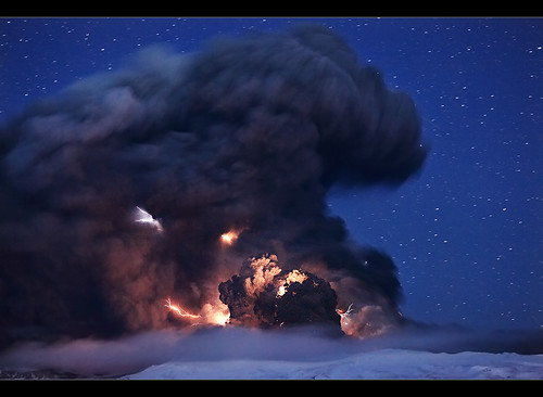
QUAKES ALSO REPORTED IN:

1. West Sumatra ( 4 perceived earthquakes, one of them (the one scaled at 5.4 M) felt in JKT)

2. Central Celebes

3. West Nusa Tenggara
Alutsyah Luthfian Create your badge

Eyjafjoll Eruption

MORE INFORMATION PLEASE REFER TO THIS LINK:
LIVE WEBCAM OF EYJAFJALLAJOKULL VOLCANO

Eruption were reported to start on March 17, 2010 The erruption in March 24-30 March were fissure type. Also, local scientist reported 4-5 active craters and 200m lava-fall into the Hruna Canyon. On March 26, the lava flow changed its course down 100m to Hvanna Canyon. From a helicopter on 28 March, scientists saw lava flowing into both canyons and noted fewer jets of lava. The next evening a swarm of earthquakes in the region measuring M 2-2.5 were detected. A geophysicist noted that seismicity was gradually decreasing. The volcano have covered an area as big as 1 square km with 10-20 m thick lava. An Earthquake scaled at 3,7 M detected in erruption zone on April 6, 2010. On April 13, 2010 eruption rate is decreased to pre-eruption level, but subglacial eruption occured on April 14, 2010 from a new vent located West of the old one. Water from melting glacier flow to N and E, causing road closures, evacuation of 700 inhabitants, and flight bannings. Iceland Police Office had reported that 25,000 people had visited the eruption site since it started on March 2010.In 16 April, 2010, Ash cloud were reported to fly as high as 30,000 ft or 9 km.
22 Lightning Strikes were observed in eruption site from April 16 2010 00.00 GMT to April 17, 2010 04.36 GMT. Some minor earthquakes measuring 1.2-2.3 on the Richter scale were also measured during that time period. The eruption continued with constant force last night but after 4:30 it was somewhat weakened. The spout reached a height of 8.5 kilometers, ruv.is reports. There is still significant ash fall in the immediate area—it is very dark at the foot of the glacier. The ash cloud is dense from Núpur in the west to Vík in the east but there is not as much ash fall in the Mýrdalssandur sand plain east of Vík anymore.

NOW (APRIL 19,2010) LIMITED AIRBORNE TRAFFIC IS PERMITTED ALL OVER EUROPE AFTER A 5-DAY BANNING!


Eyjafjoll a.k.a Eyjafjallajokul is an andesite stratovolcano with caldera in its top. This volcano lies directly on the divergent tectonic boundary which continued from South Atlantic and after passing the Iceland this boundary goes to the north pole. Along with Surtsey and Hekla, this volcano also lies in the southern shore of Iceland.

Compare Eyjafjallajokull to this VEI 6 PINATUBO ERUPTION:

How animal responding to P and S-wave

See this video. Anyone could conclude that animal can respond to P and S wave, which it not detectable to human because of its speed (P wave travels at 14 km/s in water, 300m/s in air and 50km/s in granite, and S wave at 60% of P wave). Some seconds later the main shock is perceived.

Earthquake Lights

Earthquake light is a phenomenon preceding or following an earthquake that caused by several things, these are:
1. Electric fields caused by tectonic movement of rocks containing quartz. Quartz is a piezoelectric mineral and abound in earth. Piezoelectric means that it can generate an electric field.
2. The disruption of local magnetic field. This hypothesis is not scientifically verified.
3. The light might be a result of ionization or plasma-chemical reaction of radon gas. Note that before an earthquake occur , there is unusual amount of radon gas near the epicentrum.
Long before the age of modernism, a haiku poetry made by an unknown Japanese:

The earth speaks softly
To the mountain
Which trembles
And light the sky


This light could be multicolored, reddish, or just white. Some report of earthquake lights are:
1. Reddish arc visible in Yogyakarta, Indonesia, after May 22, 2005 Earthquake. The earthquake was scaled at 6,9 M
2. Red lightning visible in Aceh, Indonesia before 2004 Boxing Day Tsunami. This lightning was so clear "like a fire". The weather was clear.
3. Mt. Kimyo Earthquake light as seen on photo in the left. It was taken by T.Kuribayashi on Sep 26, 1966. It was triggered by Matsushiro earthquake swarm occured in 1965-1969.


4. Sichuan earthquake light visible 30 minutes before the earthquake. You could find the video easily in Youtube. I'm so bored watching that video. ~_~.
5. 2007 Peru Earthquake light. Anyone may see the video below.


6.Recently, 2010 Chile Earthquake light. Residents reported that they were felt somewhat uncomfort to sleep, and then they saw "Very Bright Light" emerging from Pacific Ocean.

NEW TEAM MEMBER FOR CRSA ON AKSHAY'S GYAAN NETWORKS


I AM VERY HAPPY TO ANNOUNCE THAT CENTER OF RESEARCH OF SEISMIC ACTIVITY IS GETTING A NEW MEMBER FOR BLOG UPDATES AND EARTHQUAKES/VOLCANO RESEARCH.
HIS NAME IS

ALUTSYAH LUTHFIAN.
HE WAS BORN ON 2ND OCT 1993 IN INDONESIA. HE IS HIGHLY INTERESTED IN Cartography, Astronomical and unexplained phenomenon and geophysics, religious science WITH REGULAR UPDATES ON FACEBOOK FOR ANY EARTHQUAKES OR VOLCANIC ERRUPTIONS. ALUTH FIAN IS ALSO INTERESTED IN WEATHER AND OFTEN CONSULTS ME FOR INDONESIAN WEATHER PATTERNS

HE WILL UPDATE ON THE BLOG ALL THE LATEST EARTHQUAKES IF ANY STRIKES WITH VIDEOS AND OTHER STUFFS RELATED TO VOLCANOES. I WILL ALSO UPDATE WHEN TIME PERMITS. BUT IT CAN BE TOO DIFFICULT FOR ME TO KEEP IT GOING.

NEWS ALERT--

A VERY STRONG EARTHQUAKE OF 7.7 STRUCK IN NORTHERN SUMATRA,INDONESIA WITH A TSUNAMI WARNING ISSUED FOR INDONESIA AND INDIAN OCEAN. NO NEED TO PANIC
AKSHAY

Monday, April 5, 2010

STS 131 BEGINS


SPACE SHUTTLE DISCOVERY LAUNCHES FROM KENNEDY SPACE CENTER FLORIDA

Latest Space Shuttle News
Discovery Reaches Space
Mon, 05 Apr 2010 04:00:58 PM GMT+0530

With main engine cutoff confirmed and external fuel tank separation, space shuttle Discovery has reached orbit. The shuttle and crew lifted off from Launch Pad 39A at NASA's Kennedy Space Center in Florida as planned at 6:21 a.m. EDT. The spacecraft now begins a two-day pursuit of the International Space Station.

DISCOVERY AND CREW IS NOW IN ORBIT. ALL THE OPERATIONS WENT SMOOTH AND THE WEATHER PERMITTED!

AKSHAY

Space shuttle Discovery Ready for launch on mission STS 131

Nasa's space shuttle discovery is all set to launch from Kennedy Space Center,FL on a 14 day mission. Discovery and Crew Prepare for STS-131 Mission
Commander Alan Poindexter is set to lead the STS-131 mission to the International Space Station aboard space shuttle Discovery. Joining Poindexter will be Pilot Jim Dutton and Mission Specialists Rick Mastracchio, Clay Anderson, Dorothy Metcalf-Lindenburger, Stephanie Wilson and Naoko Yamazaki of the Japan Aerospace Exploration Agency.

Discovery will carry a multi-purpose logistics module filled with science racks for the laboratories aboard the station. The mission has three planned spacewalks, with work to include replacing an ammonia tank assembly, retrieving a Japanese experiment from the station’s exterior, and switching out a rate gyro assembly on the S0 segment of the station’s truss structure.

STS-131 will be the 33rd shuttle mission to the station.

PRESENT REPORT>>>>>>>>>>>>>>>>>>>>>>>>>>>>>.

Discovery's Fully Fueled as Hold Continues
Mon, 05 Apr 2010 10:03:38 AM UTC+0530


At Launch Pad 39A, the filling of Discovery's external fuel tank with about 500,000 gallons of chilled liquid oxygen and liquid hydrogen is now complete. These propellants will fuel the shuttle's three main engines during the ascent to space. The fueling process, known as "tanking," began at 9:28 p.m. EDT and finished at 12:21 a.m. The propellants will remain in "stable replenish" mode, keeping them filled at 100 percent throughout the remainder of the countdown.

The countdown remains in a planned hold at T-3 hours, and the clock will resume at 2:26 a.m. Both the Closeout Crew and Final Inspection Team are now on their way to Launch Pad 39A. The inspection team will conduct their top-to-bottom "walkdown" of the shuttle and pad, looking for any debris that could damage the vehicle during launch. The Closeout Crew will prepare for the astronauts' arrival at approximately 3 a.m.


STAY TUNED FOR UPDATES AT

http://www.facebook.com/pages/Severe-Solar-Weather-forecast/112556765473804