WELCOME!

WELCOME TO AKG!

FOR VIEWING SPACE WEATHER PRODUCTS CLICK HERE
AND THEN CLICK "ENTER"

-------------------------------OR-----------------------------------------
TO READ ARTICLES ON AKG BLOG OR SPACE WEATHER FORECASTS ( SEVERE SOLARWX) CLICK "ENTER" BELOW
ENTER

Wednesday, April 18, 2012

Mineralogy at A Glance

readers, i'm sorry for no pics. Made it in accordance to April 19, 2012 Mineralogy test.


Introduction


Hi readers! This time I wanna talk about mineralogy, uhm, a bit. In geophysics studies, minerals is a speaking stone. It tells us how was a layer of stone formed, what it should countain, and how old is it. A mineral is not eternal; the example being olivine. Olivine is a mineral that formed deep in the basaltic magma chamber. This green, transparent and beautiful mineral is hard. Beside its hardness, when it is put in the river, it would oxidize into another mineral called iddingsite, with different chemical composition than olivine. Another example being graphite that is compressed and heated near earth mantle, after which it changes into diamond. What making minerals ephemeral is simply the geologic processes - it changes the position of minerals in the Earth. For minerals, changing of position also means changing of thermodynamic condition and physical treatment. An igneous stone blasted by volcano, sooner or later would be carried into sea. In the sea, rock powder soon turned into layers of sediment rocks because of pressure brought by water weight. Then the plate tectonic mechanism drive the sediment to the trench and here the sediments are pressed as much as several gigapascals into metamorphic rocks. If lucky, some of the metamorphic rock is lifted again to the earth surface, creating mounts of marbles. If not, it melt again in the astenosphere, becoming magma and repeat the cycle.


How Does Minerals Form ?


Minerals are natural things, so diamonds produced at factory, instead of having near-original diamond qualities, is not called mineral. Because mineral is natural, so its forming process is always natural (not man-made). And also, differ crystal and mineral. We can grow mineral's crystal in laboratory, but we can not call that crystal as 'mineral'. Also, a volcanic lava which cools fast can not make their mineral into crystals - that's why we see igneous rock as black or gray. A black volcanic stone consist mostly of hornblende mineral while the grey one may have more mica or orthoclase mineral content.
Minerals are formed by following ways:
  1. Evaporation from solution.
  2. Gas deposition.
  3. Crystalization.
  4. Growing in solid substance.
  5. Chemical reaction between two different phases.
Explanation below:
  1. Evaporation from Solution
  2. When seawater is flowing into shallow evaporation ponds at morning, it will be heated by sun to a temperature possible for water molecule to break off connection with Na+ and Cl- and fly away to the air. After Na+ and Cl- ion break up with water, they will connect each other again to make NaCl (Halite mineral, common salt). If sea level recedes, more halite is deposited on land, creating salt pan. Sediments may bury the salt pan and geologic process fold that salt layer, because of its elasticity the salt layer may turn into a salt dome and mined by man as rock salt. Another example is calcite in caves, travertine stairs, or blotch of iron rust lining your tap in garden (that iron rust might not coming from your oxidizing tap but from acidic ground water that contain so much Fe2+ ion).
  3. Gas deposition
  4. While volcanic gases out from an erupting volcano, some of its content directly deposit into crystal. The simplest exapmle is sulphur. The deposition of sulphur is reasonable after seeing its phase diagram. Another kind of gas deposition may be occured deep in magma chamber, when bubbles of gas deep from astenosphere enter it and stick with magma chamber's outer stone roof. When sticking with the magma chamber's roof, some mineral in the gas deposited there.
  5. Crystalization
  6. In mineralogy, the term crystallization refers to magma or lava crystalizing when it reaches a spesific crystallization temperature. The magma, liquid form of igneous rock in the depth of earth's crust, crystalization process is so slow that the mineral there can grow into amazing sizes. Why so slow? What makes it slow is because the temperature of magma decreases slowly. The effect is it can maintain a spesific crystalization temperature for a very long time, say it could be hundreds of years. Lava is magma that reaches the earth's surface. Some lava cool fast and some slow, the faster it get cools, the smaller is the crystal size. Obsidian, a stone resulted from fastest cooling lava, has no crystal structure yet it have a vitreous (glassy) look. Andesite, another igneous rock, cools slower; the temperature of its parent lava may be as high as 700o C 2 weeks after the eruption ceased. The effect is andesite's mineral can be barely seen by naked eye. The slowest cooling magma, deep beneath earth surface, producing pegmatite. Minerals composing pegmatite is so big that we can analyze them one by one.
  7. Growing in solid substance
  8. This process is known to metamorphic stones. When a sedimentary or igneous stone is buried deep in earth's crust by means of geologic processes, it would face tremendous amount of heat and torturing gigapascal pressure. This coupled torment mechanism drive the molecules of rock mad. That mad molecules soon adapt to that condition (they surely can go nowhere :-D ) by reconstructing their chemical bond. When they reconstructing, it is the time when a new crystal is grow within the old one.
  9. Chemical reaction between two different phases
  10. When a solid mineral is exposed to some gases or liquid, some or all atom composing that mineral would be exchanged to that gas/liquid. This kind of chemical reaction surely resulted in new mineral with different chemical composition. For example, see the aforementioned olivine case. The hotter the reaction place, the faster it get done -> the concepts of activation energy of reaction.

So the conclusion is, mineral formation is ruled by the change of temperature or pressure surrounding the mineral. In the case of gas deposition and evaporation, the pressure contributing there is atmospheric pressure.
All mineral is starting as a small 3D molecule called nuclei. When surrounding temperature and pressure is suitable for the nuclei, the nuclei started to attract other atom possible for binding with it. The amount of possible atom + speed of temperature change + room provided in the system (remember, there are so many similar nuclei sharing limited place together) determine the shape of mineral. If the room is large, temperature change is slow and possible atom is many, a mineral can grow into a huge, perfectly shaped one.


Types of Mineral


In the earth, there are more than 4000 mineral. Broadly speaking, the 4000 mineral is divided into two main groups, the silicate and non silicate type. Further, the silicate type is divided into six group based on its molecular structure:
  1. Nesosilicates
  2. Silicate minerals composed of separated, alone SiO4 molecule.
  3. Sorosilicates
  4. Silicate minerals composed of paired two molecules of Si2O7 connected at one oxygen atom.
  5. Inosilicates
  6. Divided again into single chain inosilicates and double chain inosilicates. Single chain inosilicates are silicate minerals composed of lines of SinO3n connected at two oxygen atom. The double chain one is simply two opposing single chain connected together.
  7. Phyllosilicates
  8. Chains of inosilicates connected to its neighbors, creating a vast layer of silicate molecules. Each layer is connected to another layer via metallic ions between them.
  9. Cyclosilicates
  10. In this type of mineral, silicate molecule making a closed structure like triangle, square, or hexagonal. Ratio of Silicon versus Oxygen is 1:3.
  11. Tectosilicates
  12. Tectosilicate mineral has wireframe molecular structure; I mean that every silicate molecule bond tight with the other silicate molecule without specific structure, so that tectosilicate can resist weathering and other chemical reaction better.
About 64% of our crust is composed by silicate minerals. About 92% of mineral found in this earth is silicate type.
The other non silicate mineral is divided into 8 groups:
Mineral Group Example Mineral Picture How People Use Them

Oxides Hematite (Fe2O3) Ore of iron
Sulfides Pyrite (FeS2) Known as fool’s gold
Sulfates Gypsum (CaSO4 (+2H2O)) 
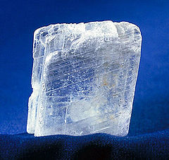
Used to make plaster
Halides Halite (NaCl) Table salt
Carbonates Calcite (CaCO3) Used to make cement
Phosphates Natrophosphate (Na7(PO4)2F.19H2O) Collection
Borates Ulexite (NaCa[B5O6(OH)6].5H2O) Natural Fiber Optic
Native Elements Sulfur(S) 
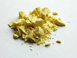
An ingredient of drugs and chemicals

Wednesday, April 11, 2012

NATURE SPARES INDIAN OCEAN! TSUNAMI WATCH LIFTED

**** TSUNAMI WATCH LIFTED FROM ALL THE AREAS OF THE INDIAN OCEAN***

**** UNCERTAINTY EXSIST WHETHER THERE WAS A TSUNAMI IN THAILAND ****

**** MULTIPLE LOW INTENSITY AFTERSHOCKS REPORTED AT OFFSHORE WEST COAST OF NORTH SUMATRA***

AKG Seismology Team-

A Major Sigh of Relief!! The Pacific Tsunami Warning Center has lifted the TSUNAMI WATCH from all the areas where it was issued- 

As per the datas from PTWC, A maximum recorded Tsunami height was 3.5ft at Meulaboh,Indonesia. Here is the report- 

MEASUREMENTS OR REPORTS OF TSUNAMI WAVE ACTIVITY

 GAUGE LOCATION        LAT   LON    TIME        AMPL         PER
 -------------------  ----- ------  -----  ---------------  -----
 MALE MV               4.2N  73.5E  1223Z   0.19M /  0.6FT  06MIN
 GAN MV                0.7S  73.2E  1212Z   0.03M /  0.1FT  48MIN
 HANIMAADHOO MV        6.8N  73.2E  1235Z   0.25M /  0.8FT  06MIN
 PADANG ID             1.0S 100.4E  1208Z   0.09M /  0.3FT  34MIN
 KO TAPHAO NOI TH      7.8N  98.4E  1143Z   0.05M /  0.2FT  06MIN
 ENGGANO ID            5.3S 102.3E  1104Z   0.12M /  0.4FT  04MIN
 TRINCONMALEE LK       8.6N  81.2E  1129Z   0.06M /  0.2FT  16MIN
 TELUKDALAM ID         0.6N  97.8E  1044Z   0.22M /  0.7FT  14MIN
 COCOS ISLAND AU      12.1S  96.9E  1102Z   0.08M /  0.3FT  18MIN
 SABANG ID             5.8N  95.3E  1010Z   0.36M /  1.2FT  06MIN
 MEULABOH ID           4.1N  96.1E  1007Z   1.06M /  3.5FT  12MIN
 DART 23401            8.9N  88.5E  0956Z   0.03M /  0.1FT  06MIN

 LAT  - LATITUDE (N-NORTH, S-SOUTH)
 LON  - LONGITUDE (E-EAST, W-WEST)
 TIME - TIME OF THE MEASUREMENT (Z IS UTC IS GREENWICH TIME)
 AMPL - TSUNAMI AMPLITUDE MEASURED RELATIVE TO NORMAL SEA LEVEL.
        IT IS ...NOT... CREST-TO-TROUGH WAVE HEIGHT.
        VALUES ARE GIVEN IN BOTH METERS(M) AND FEET(FT).
 PER  - PERIOD OF TIME IN MINUTES(MIN) FROM ONE WAVE TO THE NEXT.

However as was mentioned by AKG, Tsunami wave was generated and it reached places like Maldives,Thailand,Australia,Sri Lanka parts ( shown in PINK) in above region in additions to Indonesia.

However at these areas excluding Indonesia region not more than 1 feet of Tsunami wave was reported. The maximum was 1.06M at Meulaboh,Indonesia for 12min at 1007hrs UTC
Disaster preparedness was in full swing across 28 nations including India where people where forced to evacuate areas in Andaman and Nicobar Islands

Its obvious that a significant Tsunami was generated but location remains uncertain!

As of now, Multiple aftershocks have been reported around the epicenter region as shown by the below image

10-degree map showing recent earthquakes
Above- Each Square represents an Earthquake ( or aftershock) The two BIG BLUE SQUARES are the first earthquake (8.6M) and the aftershock of 8.2M... 

THE BIG QUESTION- WHY THERE WAS NO DESTRUCTIVE TSUNAMI??


AKG's Earthquake Expert Aluth Fian informed that this Earthquake was caused due to a transform fault which rarely generate tsunami, because tsunami is mainly resulted from height change dz -> connection to wave equation. 

Thus the plates had more horizontal movement than vertical and hence NO SIGNIFICANT Tsunami was generated. If it hadn't been the Transform Fault responsible then a significant Tsunami would had generated and quite similar to 26th Dec 2004 Event.. 


Aluth Fian shall update on the science behind this soon!


POWERFUL AFTERSHOCK HITS WEST COAST OF NORTHERN SUMATRA

AKG SEISMOLOGY-

*** POWERFUL AFTERSHOCK HITS WEST COAST OF NORTHERN SUMATRA***
*** USGC REPORTS 8.2M***


A STRONG AFTERSHOCK HAS BEEN REPORTED AT 0.773°N, 92.452°E 


AT 10:43:09 UTC


AS OF NOW, TSUNAMI IS HEADING TOWARDS THE THAILAND COAST


*************************************************************************************************************************************

UPDATED INFORMATION FROM PACIFIC TSUNAMI WARNING CENTER IS INDICATING A STRONGER TSUNAMI WAVE THAN THE PREVIOUS HITING INDONESIA COAST

TSUNAMI BULLETIN NUMBER 004
PACIFIC TSUNAMI WARNING CENTER/NOAA/NWS
ISSUED AT 1054Z 11 APR 2012

THIS BULLETIN IS FOR ALL AREAS OF THE INDIAN OCEAN.

... AN INDIAN-OCEAN-WIDE TSUNAMI WATCH IS IN EFFECT ...

... A MAJOR AFTERSHOCK OCCURRED AT 11:43Z WITH MAGNITUDE 8.3 ...

A TSUNAMI WATCH IS STILL IN EFFECT FOR

 INDONESIA / INDIA / AUSTRALIA / SRI LANKA / MYANMAR / THAILAND /
 MALDIVES / UNITED KINGDOM / MALAYSIA / MAURITIUS / REUNION /
 SEYCHELLES / OMAN / PAKISTAN / SOMALIA / MADAGASCAR / IRAN /
 UAE / YEMEN / COMORES / MOZAMBIQUE / KENYA / TANZANIA /
 CROZET ISLANDS / BANGLADESH / KERGUELEN ISLANDS / SOUTH AFRICA /
 SINGAPORE

THIS BULLETIN IS ISSUED AS ADVICE TO GOVERNMENT AGENCIES.  ONLY
NATIONAL AND LOCAL GOVERNMENT AGENCIES HAVE THE AUTHORITY TO MAKE
DECISIONS REGARDING THE OFFICIAL STATE OF ALERT IN THEIR AREA AND
ANY ACTIONS TO BE TAKEN IN RESPONSE.

AN EARTHQUAKE HAS OCCURRED WITH THESE PRELIMINARY PARAMETERS

 ORIGIN TIME -  0839Z 11 APR 2012
 COORDINATES -   2.3 NORTH   93.1 EAST
 LOCATION    -  OFF W COAST OF NORTHERN SUMATRA
 MAGNITUDE   -  8.7

MEASUREMENTS OR REPORTS OF TSUNAMI WAVE ACTIVITY

 GAUGE LOCATION        LAT   LON    TIME        AMPL         PER
 -------------------  ----- ------  -----  ---------------  -----
 TELUKDALAM ID         0.6N  97.8E  0952Z   0.15M /  0.5FT  08MIN
 SABANG ID             5.8N  95.3E  1010Z   0.36M /  1.2FT  06MIN
 MEULABOH ID           4.1N  96.1E  1007Z   1.06M /  3.5FT  12MIN
 DART 23401            8.9N  88.5E  0956Z   0.03M /  0.1FT  06MIN
 SABANG ID             5.8N  95.3E  0956Z   0.31M /  1.0FT  08MIN

 LAT  - LATITUDE (N-NORTH, S-SOUTH)
 LON  - LONGITUDE (E-EAST, W-WEST)
 TIME - TIME OF THE MEASUREMENT (Z IS UTC IS GREENWICH TIME)
 AMPL - TSUNAMI AMPLITUDE MEASURED RELATIVE TO NORMAL SEA LEVEL.
        IT IS ...NOT... CREST-TO-TROUGH WAVE HEIGHT.
        VALUES ARE GIVEN IN BOTH METERS(M) AND FEET(FT).
 PER  - PERIOD OF TIME IN MINUTES(MIN) FROM ONE WAVE TO THE NEXT.

 NOTE - DART MEASUREMENTS ARE FROM THE DEEP OCEAN AND THEY
        ARE GENERALLY MUCH SMALLER THAN WOULD BE COASTAL
         MEASUREMENTS AT SIMILAR LOCATIONS.

EVALUATION

 SEA LEVEL READINGS INDICATE A TSUNAMI WAS GENERATED. IT MAY
 ALREADY HAVE BEEN DESTRUCTIVE ALONG SOME COASTS.

 BASED ON THESE DATA THE THREAT CONTINUES FOR ALL COASTAL AREAS OF
 THE INDIAN OCEAN. FOR THOSE AREAS - WHEN NO MAJOR WAVES HAVE
 OCCURRED FOR AT LEAST TWO HOURS AFTER THE ESTIMATED ARRIVAL TIME
 OR DAMAGING WAVES HAVE NOT OCCURRED FOR AT LEAST TWO HOURS THEN
 LOCAL AUTHORITIES CAN ASSUME THE THREAT IS PASSED. DANGER TO
 BOATS AND COASTAL STRUCTURES CAN CONTINUE FOR SEVERAL HOURS DUE
 TO RAPID CURRENTS.  AS LOCAL CONDITIONS CAN CAUSE A WIDE
 VARIATION IN TSUNAMI WAVE ACTION THE ALL CLEAR DETERMINATION MUST
 BE MADE BY LOCAL AUTHORITIES.

TSUNAMI GENERATES IN THE INDIAN OCEAN!

AKG SEISMOLOGY-

*** WATER RECEDS IN THAILAND***


ABOVE- ORAWAN SANGCHAN REPORTS FROM CLOSE TO BANGKOK,THAILAND


PACIFIC TSUNAMI WARNING CENTER HAS CONFIRMED TSUNAMI WAVE GENERATION*****************

Over 1ft Tsunami Wave reported from Sabang,Indonesia


TSUNAMI LIKELY HEADING TOWARDS THAILAND


The Tsunami Wave as was anticipated has been generated! The recent update from the Pacific Tsunami Warning Center indicates the elevated Sea heights at the Northern Sumatra and vicinity


TSUNAMI BULLETIN NUMBER 003
PACIFIC TSUNAMI WARNING CENTER/NOAA/NWS
ISSUED AT 1014Z 11 APR 2012

THIS BULLETIN IS FOR ALL AREAS OF THE INDIAN OCEAN.

... AN INDIAN-OCEAN-WIDE TSUNAMI WATCH IS IN EFFECT ...

A TSUNAMI WATCH IS IN EFFECT FOR

 INDONESIA / INDIA / AUSTRALIA / SRI LANKA / MYANMAR / THAILAND /
 MALDIVES / UNITED KINGDOM / MALAYSIA / MAURITIUS / REUNION /
 SEYCHELLES / OMAN / PAKISTAN / SOMALIA / MADAGASCAR / IRAN /
 UAE / YEMEN / COMORES / MOZAMBIQUE / KENYA / TANZANIA /
 CROZET ISLANDS / BANGLADESH / KERGUELEN ISLANDS / SOUTH AFRICA /
 SINGAPORE

THIS BULLETIN IS ISSUED AS ADVICE TO GOVERNMENT AGENCIES.  ONLY
NATIONAL AND LOCAL GOVERNMENT AGENCIES HAVE THE AUTHORITY TO MAKE
DECISIONS REGARDING THE OFFICIAL STATE OF ALERT IN THEIR AREA AND
ANY ACTIONS TO BE TAKEN IN RESPONSE.

AN EARTHQUAKE HAS OCCURRED WITH THESE PRELIMINARY PARAMETERS

 ORIGIN TIME -  0839Z 11 APR 2012
 COORDINATES -   2.3 NORTH   93.1 EAST
 LOCATION    -  OFF W COAST OF NORTHERN SUMATRA
 MAGNITUDE   -  8.7

MEASUREMENTS OR REPORTS OF TSUNAMI WAVE ACTIVITY

 GAUGE LOCATION        LAT   LON    TIME        AMPL         PER
 -------------------  ----- ------  -----  ---------------  -----
 DART 23401            8.9N  88.5E  0956Z   0.03M /  0.1FT  06MIN
 MEULABOH ID           4.1N  96.1E  0950Z   0.27M /  0.9FT  14MIN
 SABANG ID             5.8N  95.3E  0956Z   0.31M /  1.0FT  08MIN

 LAT  - LATITUDE (N-NORTH, S-SOUTH)
 LON  - LONGITUDE (E-EAST, W-WEST)
 TIME - TIME OF THE MEASUREMENT (Z IS UTC IS GREENWICH TIME)
 AMPL - TSUNAMI AMPLITUDE MEASURED RELATIVE TO NORMAL SEA LEVEL.
        IT IS ...NOT... CREST-TO-TROUGH WAVE HEIGHT.
        VALUES ARE GIVEN IN BOTH METERS(M) AND FEET(FT).
 PER  - PERIOD OF TIME IN MINUTES(MIN) FROM ONE WAVE TO THE NEXT.

 NOTE - DART MEASUREMENTS ARE FROM THE DEEP OCEAN AND THEY
        ARE GENERALLY MUCH SMALLER THAN WOULD BE COASTAL
         MEASUREMENTS AT SIMILAR LOCATIONS.

EVALUATION

 SEA LEVEL READINGS INDICATE A TSUNAMI WAS GENERATED. IT MAY
 ALREADY HAVE BEEN DESTRUCTIVE ALONG SOME COASTS.

 BASED ON THESE DATA THE THREAT CONTINUES FOR ALL COASTAL AREAS OF
 THE INDIAN OCEAN. FOR THOSE AREAS - WHEN NO MAJOR WAVES HAVE
 OCCURRED FOR AT LEAST TWO HOURS AFTER THE ESTIMATED ARRIVAL TIME
 OR DAMAGING WAVES HAVE NOT OCCURRED FOR AT LEAST TWO HOURS THEN
 LOCAL AUTHORITIES CAN ASSUME THE THREAT IS PASSED. DANGER TO
 BOATS AND COASTAL STRUCTURES CAN CONTINUE FOR SEVERAL HOURS DUE
 TO RAPID CURRENTS.  AS LOCAL CONDITIONS CAN CAUSE A WIDE
 VARIATION IN TSUNAMI WAVE ACTION THE ALL CLEAR DETERMINATION MUST
 BE MADE BY LOCAL AUTHORITIES.

ESTIMATED INITIAL TSUNAMI WAVE ARRIVAL TIMES AT FORECAST POINTS
WITHIN THE WARNING AND WATCH AREAS ARE GIVEN BELOW. ACTUAL
ARRIVAL TIMES MAY DIFFER AND THE INITIAL WAVE MAY NOT BE THE
LARGEST. A TSUNAMI IS A SERIES OF WAVES AND THE TIME BETWEEN
SUCCESSIVE WAVES CAN BE FIVE MINUTES TO ONE HOUR.


 LOCATION         FORECAST POINT     COORDINATES     ARRIVAL TIME
 --------------------------------    ------------    ------------
 INDONESIA        SIMEULUE            2.5N  96.0E    0912Z 11 APR
                  BANDA_ACEH          5.5N  95.1E    0933Z 11 APR
                  SIBERUT             1.5S  98.7E    0944Z 11 APR
                  PADANG              0.9S 100.1E    1025Z 11 APR
                  BENGKULU            3.9S 102.0E    1037Z 11 APR
                  CILACAP             7.8S 108.9E    1150Z 11 APR
                  BANDAR_LAMPUNG      5.7S 105.3E    1200Z 11 APR
                  BALI                8.7S 115.3E    1234Z 11 APR
                  BELAWAN             3.8N  98.8E    1326Z 11 APR
                  KUPANG             10.0S 123.4E    1333Z 11 APR
                  BALI                8.7S 115.3E    1234Z 11 APR
 INDIA            GREAT_NICOBAR       7.1N  93.6E    0937Z 11 APR
                  LITTLE_ANDAMAN     10.7N  92.3E    1015Z 11 APR
                  NORTH_ANDAMAN      13.3N  92.6E    1045Z 11 APR
                  PORT_BLAIR         11.9N  92.7E    1050Z 11 APR
                  CHENNAI            13.4N  80.4E    1134Z 11 APR
                  TRIVANDRUM          8.3N  76.9E    1204Z 11 APR
                  KAKINADA           17.2N  82.7E    1204Z 11 APR
                  MANGALORE          13.3N  74.4E    1339Z 11 APR
                  BOMBAY             18.8N  72.6E    1605Z 11 APR
                  GULF_OF_KUTCH      22.7N  68.9E    1636Z 11 APR
 AUSTRALIA        COCOS_ISLAND       12.1S  96.7E    1046Z 11 APR
                  NORTH_WEST_CAPE    21.5S 113.9E    1312Z 11 APR
                  CAPE_INSPIRATIO    25.9S 113.0E    1413Z 11 APR
                  PERTH              32.0S 115.3E    1421Z 11 APR
                  AUGUSTA            34.3S 114.7E    1440Z 11 APR
                  GERALDTOWN         28.6S 114.3E    1456Z 11 APR
                  CAPE_LEVEQUE       16.1S 122.6E    1500Z 11 APR
                  ESPERANCE          34.0S 121.8E    1614Z 11 APR
                  KINGSTON_SOUTH_    37.0S 139.4E    1747Z 11 APR
                  HEARD_ISLAND       54.0S  73.5E    1803Z 11 APR
                  EUCLA_MOTEL        31.8S 128.9E    1824Z 11 APR
                  HOBART             43.3S 147.6E    1858Z 11 APR
                  DARWIN             12.1S 130.7E    1921Z 11 APR
 SRI LANKA        TRINCOMALEE         8.7N  81.3E    1049Z 11 APR
                  DONDRA_HEAD         5.9N  80.6E    1054Z 11 APR
                  COLOMBO             6.9N  79.8E    1121Z 11 APR
                  JAFFNA              9.9N  80.0E    1235Z 11 APR
 MYANMAR          CHEDUBA_ISLAND     18.9N  93.4E    1142Z 11 APR
                  CHEDUBA_ISLAND     18.9N  93.4E    1142Z 11 APR
                  PYINKAYAING        15.9N  94.3E    1152Z 11 APR
                  SITTWE             20.0N  92.9E    1220Z 11 APR
                  MERGUI             12.8N  98.4E    1328Z 11 APR
                  YANGON             16.5N  96.4E    1720Z 11 APR
 THAILAND         PHUKET              8.0N  98.2E    1113Z 11 APR
                  KO_PHRA_THONG       9.1N  98.2E    1203Z 11 APR
                  KO_TARUTAO          6.6N  99.6E    1233Z 11 APR
 MALDIVES         GAN                 0.6S  73.2E    1144Z 11 APR
                  MALE                4.2N  73.6E    1149Z 11 APR
                  MINICOV             8.3N  73.0E    1214Z 11 APR
 UNITED KINGDOM   DIEGO_GARCIA        7.3S  72.4E    1202Z 11 APR
 MALAYSIA         GEORGETOWN          5.4N 100.1E    1303Z 11 APR
                  PORT_DICKSON        2.5N 101.7E    1743Z 11 APR
 MAURITIUS        PORT_LOUIS         20.0S  57.3E    1500Z 11 APR
 REUNION          ST_DENIS           20.8S  55.2E    1514Z 11 APR
 SEYCHELLES       VICTORIA            4.5S  55.6E    1525Z 11 APR
 OMAN             SALALAH            16.9N  54.1E    1537Z 11 APR
                  MUSCAT             23.9N  58.6E    1544Z 11 APR
                  DUQM               19.7N  57.8E    1553Z 11 APR
 PAKISTAN         GWADAR             25.1N  62.4E    1546Z 11 APR
                  KARACHI            24.7N  66.9E    1638Z 11 APR
 SOMALIA          HILALAYA            6.4N  49.1E    1546Z 11 APR
                  CAPE_GUARO         11.9N  51.4E    1547Z 11 APR
                  MOGADISHU           2.0N  45.5E    1602Z 11 APR
                  KAAMBOONI           1.5S  41.9E    1629Z 11 APR
 MADAGASCAR       ANTSIRANANA        12.1S  49.5E    1548Z 11 APR
                  TOAMASINA          17.8S  49.6E    1601Z 11 APR
                  MANAKARA           22.2S  48.2E    1616Z 11 APR
                  MAHAJANGA          15.4S  46.2E    1652Z 11 APR
                  CAP_STE_MARIE      25.8S  45.2E    1716Z 11 APR
                  TOLIARA            23.4S  43.6E    1741Z 11 APR
 IRAN             GAVATER            25.0N  61.3E    1552Z 11 APR
 UAE              FUJAIRAH           25.1N  56.4E    1630Z 11 APR
 YEMEN            AL_MUKALLA         14.5N  49.2E    1637Z 11 APR
                  ADEN               13.0N  45.2E    1722Z 11 APR
 COMORES          MORONI             11.6S  43.3E    1649Z 11 APR
 MOZAMBIQUE       CABO_DELGADO       10.7S  40.7E    1706Z 11 APR
                  ANGOCHE            15.5S  40.6E    1738Z 11 APR
                  QUELIMANE          18.0S  37.1E    1905Z 11 APR
                  MAPUTO             25.9S  32.8E    1955Z 11 APR
                  BEIRA              19.9S  35.1E    2017Z 11 APR
 KENYA            MOMBASA             4.0S  39.7E    1706Z 11 APR
 TANZANIA         LINDI               9.8S  39.9E    1707Z 11 APR
                  DAR_ES_SALAAM       6.7S  39.4E    1710Z 11 APR
 CROZET ISLANDS   CROZET_ISLANDS     46.4S  51.8E    1734Z 11 APR
 BANGLADESH       CHITTAGONG         22.7N  91.2E    1735Z 11 APR
 KERGUELEN ISLAN  PORT_AUX_FRANCA    49.0S  69.1E    1816Z 11 APR
 SOUTH AFRICA     PRINCE_EDWARD_I    46.6S  37.6E    1907Z 11 APR
                  DURBAN             29.8S  31.2E    1910Z 11 APR
                  PORT_ELIZABETH     33.9S  25.8E    2011Z 11 APR
                  CAPE_TOWN          34.1S  18.0E    2111Z 11 APR
 SINGAPORE        SINGAPORE           1.2N 103.8E    2330Z 11 APR

8.7M EARTHQUAKE STRIKES WEST COST OF NORTHERN SUMATRA

AKG SEISMOLOGY-


MAGNITUDE 8.7 EARTHQUAKE HAS OCURED AT 08:38:38 UTC AT 2.3N,93.073E 


*** PEOPLE AT WESTERN COAST OF NORTHERN SUMATRA AND OTHER PARTS OF SUMATRA MUST PAY ATTENTION *************

THE EARTHQUAKE'S EPICENTER WAS 434 km (269 miles) SW of Banda Aceh, Sumatra, Indonesia
550 km (341 miles) SW of Lhokseumawe, Sumatra, Indonesia
963 km (598 miles) W of KUALA LUMPUR, Malaysia
1797 km (1116 miles) WNW of JAKARTA, Java, Indonesia

TREMORS WERE FELT IN MUMBAI,KOLKATA,CHENNAI ( INDIA),SINGAPORE,THAILAND,MALAYSIA AND OTHER AREAS 

City map

The above image shows that the Earthquake is a sea earthquake and has good potentials of generating a Tsunami. The Pacific Tsunami Warning Center is still waiting for confirmation of Tsunami generation and hence has put the Indian Ocean countries on Tsunami Watch!!

As of 0845z,11th April  BELOW ARE THE ESTIMATED ARRIVAL TIMES 


 LOCATION         FORECAST POINT     COORDINATES     ARRIVAL TIME
 --------------------------------    ------------    ------------
 INDONESIA        SIMEULUE            2.5N  96.0E    0921Z 11 APR
                  BANDA_ACEH          5.5N  95.1E    0931Z 11 APR
                  SIBERUT             1.5S  98.7E    0941Z 11 APR
                  PADANG              0.9S 100.1E    1017Z 11 APR
                  BENGKULU            3.9S 102.0E    1038Z 11 APR
                  CILACAP             7.8S 108.9E    1205Z 11 APR
                  BANDAR_LAMPUNG      5.7S 105.3E    1213Z 11 APR
                  BALI                8.7S 115.3E    1253Z 11 APR
                  KUPANG             10.0S 123.4E    1338Z 11 APR
                  BELAWAN             3.8N  98.8E    1348Z 11 APR
                  BALI                8.7S 115.3E    1253Z 11 APR

 INDIA            GREAT_NICOBAR       7.1N  93.6E    0937Z 11 APR
                  LITTLE_ANDAMAN     10.7N  92.3E    1016Z 11 APR
                  PORT_BLAIR         11.9N  92.7E    1032Z 11 APR
                  NORTH_ANDAMAN      13.3N  92.6E    1052Z 11 APR
                  CHENNAI            13.4N  80.4E    1127Z 11 APR
                  KAKINADA           17.2N  82.7E    1205Z 11 APR
                  TRIVANDRUM          8.3N  76.9E    1208Z 11 APR
                  MANGALORE          13.3N  74.4E    1336Z 11 APR
                  BOMBAY             18.8N  72.6E    1608Z 11 APR
                  GULF_OF_KUTCH      22.7N  68.9E    1634Z 11 APR
 SRI LANKA        DONDRA_HEAD         5.9N  80.6E    1039Z 11 APR
                  TRINCOMALEE         8.7N  81.3E    1051Z 11 APR
                  COLOMBO             6.9N  79.8E    1120Z 11 APR
                  JAFFNA              9.9N  80.0E    1231Z 11 APR
 AUSTRALIA        COCOS_ISLAND       12.1S  96.7E    1045Z 11 APR
                  NORTH_WEST_CAPE    21.5S 113.9E    1314Z 11 APR
                  CAPE_INSPIRATIO    25.9S 113.0E    1413Z 11 APR
                  PERTH              32.0S 115.3E    1420Z 11 APR
                  AUGUSTA            34.3S 114.7E    1440Z 11 APR
                  GERALDTOWN         28.6S 114.3E    1459Z 11 APR
                  CAPE_LEVEQUE       16.1S 122.6E    1506Z 11 APR
                  ESPERANCE          34.0S 121.8E    1615Z 11 APR
                  KINGSTON_SOUTH_    37.0S 139.4E    1748Z 11 APR
                  HEARD_ISLAND       54.0S  73.5E    1802Z 11 APR
                  EUCLA_MOTEL        31.8S 128.9E    1836Z 11 APR
                  HOBART             43.3S 147.6E    1901Z 11 APR
                  DARWIN             12.1S 130.7E    1935Z 11 APR
 MYANMAR          CHEDUBA_ISLAND     18.9N  93.4E    1149Z 11 APR
                  CHEDUBA_ISLAND     18.9N  93.4E    1149Z 11 APR
                  PYINKAYAING        15.9N  94.3E    1150Z 11 APR
                  SITTWE             20.0N  92.9E    1226Z 11 APR
                  MERGUI             12.8N  98.4E    1316Z 11 APR
                  YANGON             16.5N  96.4E    1507Z 11 APR
 THAILAND         PHUKET              8.0N  98.2E    1118Z 11 APR
                  KO_PHRA_THONG       9.1N  98.2E    1223Z 11 APR
                  KO_TARUTAO          6.6N  99.6E    1256Z 11 APR
 MALDIVES         GAN                 0.6S  73.2E    1137Z 11 APR
                  MINICOV             8.3N  73.0E    1210Z 11 APR
                  MALE                4.2N  73.6E    1211Z 11 APR
 UNITED KINGDOM   DIEGO_GARCIA        7.3S  72.4E    1153Z 11 APR
 MALAYSIA         GEORGETOWN          5.4N 100.1E    1311Z 11 APR
                  PORT_DICKSON        2.5N 101.7E    1810Z 11 APR
 MAURITIUS        PORT_LOUIS         20.0S  57.3E    1455Z 11 APR
 REUNION          ST_DENIS           20.8S  55.2E    1512Z 11 APR
 SEYCHELLES       VICTORIA            4.5S  55.6E    1516Z 11 APR
 PAKISTAN         GWADAR             25.1N  62.4E    1536Z 11 APR
                  KARACHI            24.7N  66.9E    1644Z 11 APR
 SOMALIA          CAPE_GUARO         11.9N  51.4E    1539Z 11 APR
                  HILALAYA            6.4N  49.1E    1540Z 11 APR
                  MOGADISHU           2.0N  45.5E    1558Z 11 APR
                  KAAMBOONI           1.5S  41.9E    1623Z 11 APR
 OMAN             MUSCAT             23.9N  58.6E    1540Z 11 APR
                  SALALAH            16.9N  54.1E    1547Z 11 APR
                  DUQM               19.7N  57.8E    1556Z 11 APR
 MADAGASCAR       ANTSIRANANA        12.1S  49.5E    1544Z 11 APR
                  TOAMASINA          17.8S  49.6E    1551Z 11 APR
                  MANAKARA           22.2S  48.2E    1610Z 11 APR
                  MAHAJANGA          15.4S  46.2E    1653Z 11 APR
                  CAP_STE_MARIE      25.8S  45.2E    1713Z 11 APR
                  TOLIARA            23.4S  43.6E    1733Z 11 APR
 IRAN             GAVATER            25.0N  61.3E    1546Z 11 APR
 UAE              FUJAIRAH           25.1N  56.4E    1621Z 11 APR
 YEMEN            AL_MUKALLA         14.5N  49.2E    1626Z 11 APR
                  ADEN               13.0N  45.2E    1726Z 11 APR
 COMORES          MORONI             11.6S  43.3E    1644Z 11 APR
 BANGLADESH       CHITTAGONG         22.7N  91.2E    1651Z 11 APR
 TANZANIA         LINDI               9.8S  39.9E    1659Z 11 APR
                  DAR_ES_SALAAM       6.7S  39.4E    1732Z 11 APR
 MOZAMBIQUE       CABO_DELGADO       10.7S  40.7E    1701Z 11 APR
                  ANGOCHE            15.5S  40.6E    1720Z 11 APR
                  QUELIMANE          18.0S  37.1E    1841Z 11 APR
                  MAPUTO             25.9S  32.8E    1959Z 11 APR
                  BEIRA              19.9S  35.1E    2016Z 11 APR
 KENYA            MOMBASA             4.0S  39.7E    1706Z 11 APR
 CROZET ISLANDS   CROZET_ISLANDS     46.4S  51.8E    1733Z 11 APR
 KERGUELEN ISLAN  PORT_AUX_FRANCA    49.0S  69.1E    1815Z 11 APR
 SOUTH AFRICA     PRINCE_EDWARD_I    46.6S  37.6E    1907Z 11 APR
                  DURBAN             29.8S  31.2E    1910Z 11 APR
                  PORT_ELIZABETH     33.9S  25.8E    2006Z 11 APR
                  CAPE_TOWN          34.1S  18.0E    2109Z 11 APR
 SINGAPORE        SINGAPORE           1.2N 103.8E    2351Z 11 APR

MAJOR EARTHQUAKE (8.7M) STRIKES WEST COAST OF NORTHERN SUMATRA... TSUNAMI WATCH IN EFFECT

Earthquake Location


MAJOR EARTHQUAKE AT THE WEST COAST OF NORTHERN SUMATRA


****** 8.7M REPORTED BY USGC*********


*TSUNAMI WATCH IN EFFECT FOR MULTIPLE AREAS LIKE 


**** TSUNAMI GENERATION NOT CONFIRMED YET*****


EXPECTED TSUNAMI ARRIVAL TIMES BELOW


A TSUNAMI WATCH IS IN EFFECT FOR INDONESIA / INDIA / SRI LANKA / AUSTRALIA / MYANMAR / THAILAND / MALDIVES / UNITED KINGDOM / MALAYSIA / MAURITIUS / REUNION / SEYCHELLES / PAKISTAN / SOMALIA / OMAN / MADAGASCAR / IRAN / UAE / YEMEN / COMORES / BANGLADESH / TANZANIA / MOZAMBIQUE / KENYA / CROZET ISLANDS / KERGUELEN ISLANDS / SOUTH AFRICA / SINGAPORE


 LOCATION         FORECAST POINT     COORDINATES     ARRIVAL TIME
 --------------------------------    ------------    ------------
 INDONESIA        SIMEULUE            2.5N  96.0E    0921Z 11 APR
                  BANDA_ACEH          5.5N  95.1E    0931Z 11 APR
                  SIBERUT             1.5S  98.7E    0941Z 11 APR
                  PADANG              0.9S 100.1E    1017Z 11 APR
                  BENGKULU            3.9S 102.0E    1038Z 11 APR
                  CILACAP             7.8S 108.9E    1205Z 11 APR
                  BANDAR_LAMPUNG      5.7S 105.3E    1213Z 11 APR
                  BALI                8.7S 115.3E    1253Z 11 APR
                  KUPANG             10.0S 123.4E    1338Z 11 APR
                  BELAWAN             3.8N  98.8E    1348Z 11 APR
                  BALI                8.7S 115.3E    1253Z 11 APR
 INDIA            GREAT_NICOBAR       7.1N  93.6E    0937Z 11 APR
                  LITTLE_ANDAMAN     10.7N  92.3E    1016Z 11 APR
                  PORT_BLAIR         11.9N  92.7E    1032Z 11 APR
                  NORTH_ANDAMAN      13.3N  92.6E    1052Z 11 APR
                  CHENNAI            13.4N  80.4E    1127Z 11 APR
                  KAKINADA           17.2N  82.7E    1205Z 11 APR
                  TRIVANDRUM          8.3N  76.9E    1208Z 11 APR
                  MANGALORE          13.3N  74.4E    1336Z 11 APR
                  BOMBAY             18.8N  72.6E    1608Z 11 APR
                  GULF_OF_KUTCH      22.7N  68.9E    1634Z 11 APR
 SRI LANKA        DONDRA_HEAD         5.9N  80.6E    1039Z 11 APR
                  TRINCOMALEE         8.7N  81.3E    1051Z 11 APR
                  COLOMBO             6.9N  79.8E    1120Z 11 APR
                  JAFFNA              9.9N  80.0E    1231Z 11 APR
 AUSTRALIA        COCOS_ISLAND       12.1S  96.7E    1045Z 11 APR
                  NORTH_WEST_CAPE    21.5S 113.9E    1314Z 11 APR
                  CAPE_INSPIRATIO    25.9S 113.0E    1413Z 11 APR
                  PERTH              32.0S 115.3E    1420Z 11 APR
                  AUGUSTA            34.3S 114.7E    1440Z 11 APR
                  GERALDTOWN         28.6S 114.3E    1459Z 11 APR
                  CAPE_LEVEQUE       16.1S 122.6E    1506Z 11 APR
                  ESPERANCE          34.0S 121.8E    1615Z 11 APR
                  KINGSTON_SOUTH_    37.0S 139.4E    1748Z 11 APR
                  HEARD_ISLAND       54.0S  73.5E    1802Z 11 APR
                  EUCLA_MOTEL        31.8S 128.9E    1836Z 11 APR
                  HOBART             43.3S 147.6E    1901Z 11 APR
                  DARWIN             12.1S 130.7E    1935Z 11 APR
 MYANMAR          CHEDUBA_ISLAND     18.9N  93.4E    1149Z 11 APR
                  CHEDUBA_ISLAND     18.9N  93.4E    1149Z 11 APR
                  PYINKAYAING        15.9N  94.3E    1150Z 11 APR
                  SITTWE             20.0N  92.9E    1226Z 11 APR
                  MERGUI             12.8N  98.4E    1316Z 11 APR
                  YANGON             16.5N  96.4E    1507Z 11 APR
 THAILAND         PHUKET              8.0N  98.2E    1118Z 11 APR
                  KO_PHRA_THONG       9.1N  98.2E    1223Z 11 APR
                  KO_TARUTAO          6.6N  99.6E    1256Z 11 APR
 MALDIVES         GAN                 0.6S  73.2E    1137Z 11 APR
                  MINICOV             8.3N  73.0E    1210Z 11 APR
                  MALE                4.2N  73.6E    1211Z 11 APR
 UNITED KINGDOM   DIEGO_GARCIA        7.3S  72.4E    1153Z 11 APR
 MALAYSIA         GEORGETOWN          5.4N 100.1E    1311Z 11 APR
                  PORT_DICKSON        2.5N 101.7E    1810Z 11 APR
 MAURITIUS        PORT_LOUIS         20.0S  57.3E    1455Z 11 APR
 REUNION          ST_DENIS           20.8S  55.2E    1512Z 11 APR
 SEYCHELLES       VICTORIA            4.5S  55.6E    1516Z 11 APR
 PAKISTAN         GWADAR             25.1N  62.4E    1536Z 11 APR
                  KARACHI            24.7N  66.9E    1644Z 11 APR
 SOMALIA          CAPE_GUARO         11.9N  51.4E    1539Z 11 APR
                  HILALAYA            6.4N  49.1E    1540Z 11 APR
                  MOGADISHU           2.0N  45.5E    1558Z 11 APR
                  KAAMBOONI           1.5S  41.9E    1623Z 11 APR
 OMAN             MUSCAT             23.9N  58.6E    1540Z 11 APR
                  SALALAH            16.9N  54.1E    1547Z 11 APR
                  DUQM               19.7N  57.8E    1556Z 11 APR
 MADAGASCAR       ANTSIRANANA        12.1S  49.5E    1544Z 11 APR
                  TOAMASINA          17.8S  49.6E    1551Z 11 APR
                  MANAKARA           22.2S  48.2E    1610Z 11 APR
                  MAHAJANGA          15.4S  46.2E    1653Z 11 APR
                  CAP_STE_MARIE      25.8S  45.2E    1713Z 11 APR
                  TOLIARA            23.4S  43.6E    1733Z 11 APR
 IRAN             GAVATER            25.0N  61.3E    1546Z 11 APR
 UAE              FUJAIRAH           25.1N  56.4E    1621Z 11 APR
 YEMEN            AL_MUKALLA         14.5N  49.2E    1626Z 11 APR
                  ADEN               13.0N  45.2E    1726Z 11 APR
 COMORES          MORONI             11.6S  43.3E    1644Z 11 APR
 BANGLADESH       CHITTAGONG         22.7N  91.2E    1651Z 11 APR
 TANZANIA         LINDI               9.8S  39.9E    1659Z 11 APR
                  DAR_ES_SALAAM       6.7S  39.4E    1732Z 11 APR
 MOZAMBIQUE       CABO_DELGADO       10.7S  40.7E    1701Z 11 APR
                  ANGOCHE            15.5S  40.6E    1720Z 11 APR
                  QUELIMANE          18.0S  37.1E    1841Z 11 APR
                  MAPUTO             25.9S  32.8E    1959Z 11 APR
                  BEIRA              19.9S  35.1E    2016Z 11 APR
 KENYA            MOMBASA             4.0S  39.7E    1706Z 11 APR
 CROZET ISLANDS   CROZET_ISLANDS     46.4S  51.8E    1733Z 11 APR
 KERGUELEN ISLAN  PORT_AUX_FRANCA    49.0S  69.1E    1815Z 11 APR
 SOUTH AFRICA     PRINCE_EDWARD_I    46.6S  37.6E    1907Z 11 APR
                  DURBAN             29.8S  31.2E    1910Z 11 APR
                  PORT_ELIZABETH     33.9S  25.8E    2006Z 11 APR
                  CAPE_TOWN          34.1S  18.0E    2109Z 11 APR
 SINGAPORE        SINGAPORE           1.2N 103.8E    2351Z 11 APR

Hyper Quiet Space Weather!!!

SEVERE SOLARWX
AKSHAY DEORAS
SEVERE WEATHER FORECASTER

300TH ARTICLE

*** THE EARTH FACING SIDE OF THE SUN IS BLANK AT PRESENT***
*** NO SUNSPOT ON THE EARTH FACING SIDE OF THE SUN***
*** DAILY SUNSPOT NO. AS LOW AS 24 TODAY***


The progress of Solar Cycle 24 had been satisfactory in the month of March especially due to the elevated activity due to Sunspot 1429. However the spaceweather has turned flat in April 


The March 2012 monthly sunspot no has been 64.2 as against the expected 75.8. However as compared to the Feb 2012 sunspot no which was 33.1 only there has been almost doubling in March!

With the present scenario, the April sunspot no is sure to be less depending on how the Sunspots form this
month. On the back side of the Sun, there are many sunspots and many are active! These sunspots shall rotate on the Earthside of the Sun in around a week from now and interesting space weather may be expected the next week so staty tuned for the updates!


Sunday, April 1, 2012

AKG LAUNCHES SEVERE SOLARWX PAGE

SELF UPDATING PAGE ON SPACE WEATHER PRODUCTS LAUNCHED ON AKG


SEVERE SOLARWX PAGE WILL PROVIDE REALTIME CONDITION SUCH AS SOLAR WIND,KP INDICES,REAL TIME IMAES OF SUN,CME,IMF


WHENEVER YOU ENTER THE BLOG, YOU WILL BE ASKED WHETHER YOU WANT TO VIEW THE REAL TIME CONDITIONS OR CHECK THE LATEST ARTICLES/FORECASTS ON THE BLOG. 


FOR VIEWING SPACE WEATHER DATA-


CLICK ON THE FIRST OPTION OF "CLICK HERE" WHICH WILL RE-DIRECT YOU TO SEVERE SOLARWX PAGE AND THEN CLICK ENTER


FOR VIEWING OTHER ARTICLES,SIMPLY CLICK ENTER WHICH WILL TAKE YOU TO THE MAIN PAGE OF THE BLOG


THE NEW DATAS ARE IN COLLABORATION WTH SWPC,SDO,STEREO 


STAY TUNED FOR UPDATES AT

http://www.facebook.com/pages/Severe-Solar-Weather-forecast/112556765473804